
Deep-Sea Images Give New View of Arctic Ocean Methane Seeps
July 7, 2015
Working with colleagues from the Centre for Arctic Gas Hydrate, Environment and Climate (CAGE) in Norway, Dan Fornari from Woods Hole Oceanographic Institution’s (WHOI) Geology & Geophysics Department collected nearly 30,000 high definition images at known methane release sites in the Arctic Ocean north of Norway. The detailed images will provide new insights into the most remote areas of natural methane releases in the world.
Guided by the new sampling and imaging system developed by Fornari with CAGE colleagues, the research team collected seafloor sediment samples of gas hydrate—methane trapped in a solid ice-like structure stored in sediments in the ocean floor—during the two-week expedition in May.
“We have taken so many samples all over these areas, but we were sampling blind. We needed to see what was going on down there,” said expedition leader Giuliana Panieri of CAGE. “This is the first time that we have seen these methane seeps in the deep Arctic Ocean areas. The images are amazing.”
Utilizing technology based on the WHOI MISO Facility’s towed deep-sea camera system (TowCam), Fornari converted CAGE’s multicoring system to permit real time imaging in addition to sediment core sampling, bottom water sampling, and conductivity, temperature, and depth (CTD) data acquisition. During the cruise, the system was used to guide sampling so that the cores would be taken directly from areas where seafloor exposures of gas hydrate were observed. Images and samples were collected at seven different areas of known active seep sites between ~78-80°N in the Norwegian Arctic, including the Vestnesa Ridge, which has over 1,000 methane seeps at a depth of more than 1,000 meters (3,281 feet).
The TowCam system development, which was funded by the U.S. National Science Foundation, is an internally recording, 16 megapixel digital-still, deep-sea camera system that can also acquire sediment and seawater samples and provide low-resolution, real-time imaging through the application of network extending technology that was developed at WHOI by Marshall Swartz of WHOI’s Physical Oceanography Dept. TowCam’s imaging system consists of a color still camera that takes high resolution photographs every 10 to 15 seconds as the ship is traveling at ~1/4 to 1/2 knot speed. After the TowCam is lowered over the side of a ship, it is “flown” at about 5 meters (16 feet) altitude above the seafloor using a conducting CTD cable connected to the ship. The system is raised and lowered over seafloor topography by hauling in and paying out on a deep-sea winch that stores the CTD cable. On the Arctic expedition, the midnight sun allowed for TowCam to be deployed 24 hours a day, providing scientists with data that will be crucial in new discoveries in years to come.
“I’m thrilled that the TowCam performed so well and that we were able to provide a new perspective to our colleagues in Norway,” said Dan Fornari, a geologist at WHOI and one of the principle developers of the system. “They have a lot of data based mostly on geophysical studies, but with the new data they will able to link that to actual geological observations of the sea floor. It’s a huge leap forward.”
While gas hydrates are stable under high pressure and low temperature conditions, they can breakdown as ocean temperatures warm and sea ice retreats. In the Arctic, glaciers and permafrost act as a “cap” to help prevent leaking methane—a potent greenhouse gas—from escaping into the atmosphere.
“Warming in the Arctic could have a destabilizing effect on methane hydrates,” said Adam Soule, a geologist and chief scientist for the National Deep Submergence Facility at WHOI. “In order to understand that potential, we need to know more about how the entire process works, which requires a presence beyond taking sediment samples. The next step in understanding the system requires visual observations that can only be achieved with cameras and deep submergence vehicles.”
#
The Centre for Arctic Gas Hydrate, Environment and Climate is a world leader in gas hydrate research, laying the foundation for understanding how methane release impacts the marine environment and climate system. For more information about CAGE, visit https://cage.uit.no/
The Woods Hole Oceanographic Institution is a private, non-profit organization on Cape Cod, Mass., dedicated to marine research, engineering, and higher education. Established in 1930 on a recommendation from the National Academy of Sciences, its primary mission is to understand the ocean and its interaction with the Earth as a whole, and to communicate a basic understanding of the ocean’s role in the changing global environment. For more information, please visit www.whoi.edu.
Nearly 30,000 high definition images of the deep Arctic Ocean floor were captured during the two-week expedition in May, giving new insights into the most remote areas of natural methane release in the world.
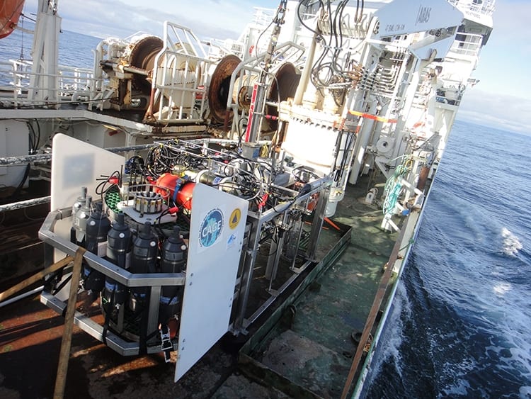
Utilizing technology based on the WHOI MISO Facility's towed deep-sea camera system (TowCam), Fornari converted CAGE's multicoring system to permit real time imaging in addition to sediment core sampling, bottom water sampling, and conductivity, temperature, and depth (CTD) data acquisition.
(Dan Fornari, Woods Hole Oceanographic Institution)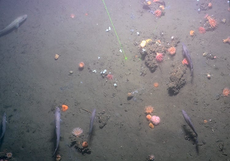
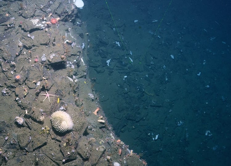
The seafloor at 500 meters water depth. Carbonate blocks are colonized by anemones and sponges. Tube worms are abundant at the seafloor. In the upper part of the image, we see patches of bacterial mats. All of these features are indigenous to sites of methane release.
(Centre for Arctic Gas Hydrate, Environment and Climate)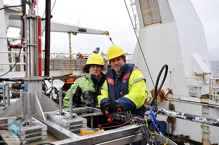
Giuliana Panieri of CAGE and Dan Fornari of WHOI with the TowCam multicoring system aboard research vessel Helmer Hanssen. Fornari developed the system and adapted it to CAGE platform. During the cruise, it was used to guide sampling so that the cores would be taken directly from areas where seafloor exposures of gas hydrate were observed.
(E. Astrom, Centre for Arctic Gas Hydrate, Environment and Climate)