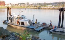
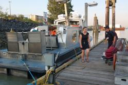
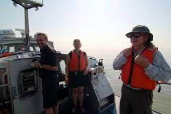
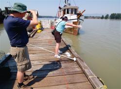
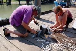
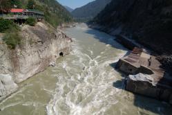
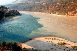
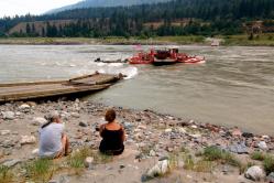
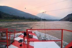
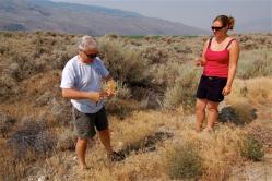
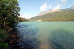
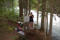
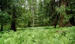
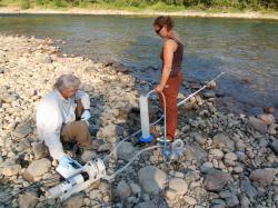
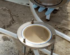
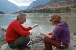
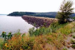
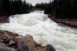
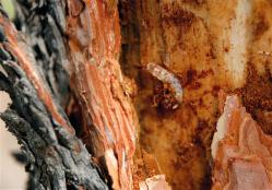
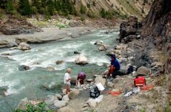
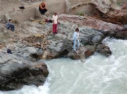
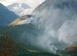
Monday, July 27: We met Sharon Gillies (head of the Biology Dept. at UFV) and Bob at the Shipping and Receiving Dept. to locate our gear and pack the van for two days of work in the delta. The "dipper" hadn't arrived, which made me a bit nervous, but everything else was there. We drove back to Vancouver to pick up some stuff at the University of British Columbia (UBC), including a large funnel to wash the "thick cakes of suspended sediment trapped on the filters" in suitable storage containers (or so we thought...) Then, we headed to the warehouse at the Annacis Facility of the Fraser Port Authority to store our gear for the next two days. Nelly Francois (Port Metro Vancouver) introduced us to Wayne who helped us unload and gave us space in the warehouse. The support was great. Tuesday, July 28: We met Captain Steve Davis (Harbor Patrol Boatmaster) and Mate Norbert who invited us on board the "Port Fraser", one of the patrol boats operated by the Fraser Port Authority. This is a fast boat with a shallow draft, ideal for working on the river. Steve led us to a good location for sampling outside of the salt water wedge, just East of the Annacis Island. That's where things got interesting: They also call the "Mighty Fraser" the "Muddy Fraser" - for a good reason. Our membrane filters clogged very rapidly and no thick cake of suspended sediment built up on the filter surfaces. Without getting into the details, filtering large volumes of river water to retrieve a sufficiently large mass for compound-specific isotope work was not successful with our filtration setup. Instead, we got good samples of the bedload with our grab sampler from two locations. We also got excellent water samples. The day was hot and humid again. I think the all-time temperature record for Vancouver was broken today. Wednesday, July 29: We went out again on the "Port Fraser", this time to Sand Heads where the Fraser meets the Straight of Georgia. We took two grab samples in adjacent locations and steamed back to port. Seeing the western portion of the delta was really interesting. After loading our gear back into our van at the warehouse and saying good-bye to Steve, Norbert and Wayne, we headed East to Abbotsford. Another hot and humid day. Thursday, July 30: Today we met with Sharon Gillies and Steven Marsh (Geography Dept.) at UFV to select a suitable sampling location for the time-series sampling. After looking at two sites near Mission on opposite sides of the Fraser, we drove to Fort Langley. The dock facilities near the ferry terminal looked ideal for time-series sampling - easy access even during the freshet, location near Sharon's home, good deep water access. We showed Sharon and Steve the first part of the sampling routine and both passed the "dipper exam" with flying colors. We finished the full sampling procedure after about three hours (except the large volume filtration for suspended particulate matter). The full sampling consists of in-situ measurements of pH, dissolved oxygen, total dissolved solids (conductivity) and temperature, filtered (glass fiber filters) water samples for the inorganic carbon system, dissolved organic carbon and nitrogen, DO13C, DO14C, DI14C, GFF filters for POC total lipid extract, oxygen isotopes in river water, nutrient analyses, major cations and anions, "dipper" cartridge-syringe filtration for dissolved Sr isotopes (maybe Os isotopes), particulate Sr and Nd isotopes, and 47 mm all-plastic filtration for trace element analyses and (possibly) some other stable inorganic isotope systems. We also occasionally take samples for OM incubation experiments. This was another hot and humid day, with record temperatures in Vancouver and the Fraser Valley. While we selected Fort Langley as our primary time-series site, we may have another time-series site closer to the delta in New Westminster. Alida kindly offered to support this station near her home. Friday, July 31: We drove to UFV to repack our gear for the trip into the headwaters of the Fraser River. Bob in Shipping & Receiving provided expert support and we were on the road before noon to sample to Harrison River at Kilby Park north of Chilliwack. The Harrison is one of the last major tributaries to joins the Fraser River before the delta. The other major tributary after the confluence of the Harrison with the Fraser is the Pitt River. We spend about 2.5 hours on the shore of the Harrison River to complete the full station program. Britta easily passed the "dipper exam". The 1000 W Honda generator is great to have in the field - very quiet, portable, yet powerful. The peristaltic pump with the two pump heads is also working very well in combination with the Tygon tubing and the generator. We filled up the car for the longer trip tomorrow. The goal for Saturday is to reach Lytton on the confluence of the Thompson River with the Fraser River and complete a full station on the Thompson River. The Thompson is the largest tributary of the Fraser, and we hope to get good access to it in Lytton. Saturday, August 1: We had a great sampling day in Lytton at the confluence of the Thompson River, the largest tributary of the Fraser, and the Fraser itself. We managed to do two full stations, one in the heat of the day (Lytton is Canada's hotspot) and one in the evening. In the evening the wind had changed directions and blew upriver, so that the smoke from the forest fires upstream was pushed back and didn't bother us much. At the end of the day we rode the ferry across the Fraser and back. That ferry is tied to a cable and crosses the river without power by simply changing the angle of the boat to the current. The current is strong - easily 5 knots. Sunday, August 2: We decided to head into the mountains to sample the headwaters. This will allow us to circumvent the wildfires and return to the locations north of Lytton on our way back. We hope that the fires will be put out by then. The drive was long, through semi-desert along the Thompson and North Thompson Rivers (sagebrush and bighorn sheep country), but we finally made it to McBride on the upper Fraser. Tomorrow we will visit the Continental Divide and then pick two locations (one tributary - Robson River) and one mainstem location. Monday, August 3, 2009: Today we went to the continental divide to explore the beginnings of the Fraser river up in the Rocky Mountains. While we didn't hike into the headwaters, we managed to sample the Fraser about 50 km downstream of it's source. In the afternoon we drove to Robson River, one of the main glacial tributaries of the Fraser that joins the mainstem south of Mount Robson, the highest peak in the Canadian Rockies. Mount Robson is a fabulous sight - a 2000+ m high near vertical wall on the south side. We had a great sampling location right on the cool banks of this fast-flowing tributary. The melting up on the glaciers is in full swing and the flow is highest in the early afternoon. We got good rock flour on our filters, but probably little organic matter... The weather is cooler up here in the Rockies, we even had a light rain shower on our way back. Tomorrow we will follow the Fraser downstream and stay in Prince George for a couple of nights to sample some of the major tributaries. Tuesday, August 4, 2009: We left McBride this morning, after sampling the Fraser near Highway 16. The mosquitoes were very active all day, particularly at our next Fraser River sampling location at the bridge across the Fraser at Hansard, a location that is connected to Highway 16 by a long gravel road. In between we stopped at the "Ancient Forest", a small area of preserved temperate rainforest on the northern slopes of the Caribou Mountains. Some of the cedars are apparently up to 2000 years old. This area stands in marked contrast to the widespread clear-cutting that dominates large tracts of the Fraser River basin. We also explored the access road to the McGregor River, one of the main tributaries of the Fraser from the Rocky Mountains and will do a full station there (with duplicates) tomorrow. Our base station for today and the next 2-3 nights is the regional center Prince George. We hope to sample another tributary - the Nechako River - on Thursday, sample the Fraser main stem again, and possibly also sample the Stuart River that joins the Nechako from the North. We may also explore the area of the Kenny Dam that diverts a significant fraction of the Nechako to the west to provide power to the ALCAN aluminum production site on the Pacific Coast. After that we hope that the wildfires in the south have been put out to allow us access to the Chilcotin, the Blackwater, and the Quesnel rivers. However, Lillooet, the town we had chosen as our base has been evacuated two days ago. The fire danger is at its highest level for the last few days. Wednesday, August 5, 2009: We drove to the McGregor this morning, one of the main tributaries to the Fraser that drains the western side of the Rocky Mountains. Parts of the headwaters are glacier-fed, and the water is relatively cool (13 degrees C). Getting to this somewhat remote place took some time, but once there we had a great sampling station with many duplicates - and few mosquitoes. In the afternoon we explored potential sampling sites on two other tributaries that drain the Cariboo Mountains - Willow River and Bowron River. While we identified a good site for the Willow River, Daniel didn't like the very much alive large particulate organic matter playing on the shores - we decided to come back tomorrow hoping that the party will have ended. Instead, we found a great site for sampling Bowron River, the clearest tributary yet. Daniel filtered nearly 90 liters through one large GFF, and Britta and I used only a single 47 mm filter to fill our 1-liter HDPE bottle, and could continue filtering to load the filter with the good stuff. The fires near Lillooet are still very active and the evacuation order is still in place. We'll have two more days in this area to sample the Nechako, the Stuart and the Willow Rivers, but then we need to head south towards the forest fires in order to reach our next sampling locations. Thursday, August 6, 2009: Today, the two sampling locations on tributaries were within easy reach of Prince George. We sampled the Willow River in the morning (no large particulate organic carbon on the beach) and the Nechako in the early afternoon. Both sites were so accessible that we could leave our generator next to the car. We've developed a certain routine for "doing a station": Britta and I get the dipper ready and fill two 125 ml bottles with 0.22 and 0.45 micron cartridge-filtered water. Then we press as much water through the cartridges until they clog. We hope to use the trapped particles for inorganic isotope analyses. While Britta and I are busy with the dipper, Daniel is setting up the generator, the peristaltic pump and all the rest of the equipment he needs for the large glass fiber filter (GFF) setup (for organic matter). He probably does most of the schlepping, and hooking up the cables etc (he certainly is our cable guy). When we are done with the dipper we secure the tygon tubing to the dipper as our water intake and put it away from the shore into deeper water (if possible). After the tubing and filter holder are flushed Daniel puts a GFF into the holder and starts filtering. While we are pumping as much water through the GFF as possible, we fill the various bottles (organic carbon, 14C, DIC-Alkalinity, bottles for nutrients, major ions, duplicate bottles, sometimes large bottles for incubation experiments (for Max) etc. Some of these are put on ice immediately after filtration. We then rinse a zip-lock bag for the 47 mm filters and put it aside. While this is being done, we are putting labels on the bottles, fixing a GPS location, taking photographs of the site, and using Max's YSI meter to determine temperature, dissolved oxygen, total dissolved solids, and pH. At the end of the GFF filtration we pump as much water through the filter as possible. The total volume can vary from 10 to about 90 liters. After that Daniel disassembles the GFF filter holder and we collect an unfiltered water sample for oxygen isotope analysis of the water (for Max). Then we switch over to an all-plastic 47 mm filter holder and collect at least one 1-liter bottle for trace element/isotope analyses. This may require up to 6 filters, depending on the turbidity of the water, and can take quite a while. We save the filters in the washed zip-lock bag for inorganic analyses. After that we are done. Breakdown takes just a few minutes, and then we are back on the road again. Initially, this process took us close to three hours. Today we completed both stations in little over 90 minutes. Over night we try to use the fridges to freeze samples, and then put them back in the ice-water mix (cooler box) before we hit the road. The evenings are also great for planning the coming day, making reservations, and for writing the daily updates. Tomorrow we will head to the Stuart River, the main tributary of the Nechako that drains the northern peneplain. We then head west to the Kenny dam – but more about that tomorrow. Friday, August 7, 2009: We drove to our northernmost sampling location today, not quite 55 degrees N on the Stuart River. This should have been easy, but it turned out that the town of Fort St. James discharges its sewage outfall directly into the Stuart River. Not being able to find anyone at town hall with information on the exact location of the pipe and the discharge operation, we settled for sampling Stuart Lake that is feeding Stuart River. This was (and hopefully will remain) our only lake sampling site. After completing our work in Fort St. James we drove back to Vanderhoof (west of Prince George) and decided to make the trip out to the Kenny Dam. The gravel roads were well maintained and it took us only little more than one hour to reach the dam - at the time of its construction (late 1940s, early 1950s) it was the largest earthen dam on Earth. It blocks the flow of the upper Nechako River, one of the main tributaries to the Fraser and sustains a huge ring-like lake structure that is used by ALCAN to produce hydro-power for their Al-smelter in Kitimat on the Pacific Coast. About 3/4 of the natural flow of the Nechako is thus diverted to the Pacific through a mountain tunnel and underground turbine installations at Kemano on the Pacific Coast. The upper Nechako valley has been flooded in the early 1950s over a few years without removing the timber first, and with giving the local population little warning and insufficient compensation for their land. In order to maintain conditions acceptable for salmon, ALCAN has agreed to use the spillway (Chesletta Lake) to release cool lake water into the Nechako if water temperatures rise above acceptable levels (salmon don't like temperatures above 18 degrees C). Due to the high temperatures the spillway was open when we visited Chesletta Falls – a series of tremendous rapids delivering water into the Nechako River. All along our drive out to the Kenny dam we saw the devastating effects of the pine beetle infestations that have plagued the Fraser River basin for the past decade. Entire sections of the forest are dead and the timber companies can't harvest the wood fast enough to at least save the value of the timber before it starts to rot. With the forest fires still raging farther south the basin has its share of problems right now. To our surprise, we found a Swiss lodge near Kenny Dam that operates a small restaurant by the lake (Nachako Lodge, owned and operated by Joe & Elisabeth Doerig). We are now heading south, aiming for a sample of the Fraser at Stoner south of Prince George and then another tributary - the Blackwater (also called West Road) River. Saturday, August 8th, 2009: We sampled the Fraser River at Stoner today to get an integrated picture of all the tributaries upstream of Prince George. The location at a Swiss-operated RV Park was nearly ideal, and the weather not too hot. After that we drove to Quesnel where it was significantly warmer. We checked into our motel and went on another gravel road trip to Blackwater west of Quesnel in the afternoon. It rained hard for the first time since we've been on the road - our car certainly benefited from the wash. Blackwater is a tiny community near the Blackwater River, and we found a secluded camp site next to the river to set up our station. The pH of this river was the highest measured thus far (8.8) - most of the tributaries and the Fraser are slightly alkaline, often around pH 8. The temperature of the Blackwater (19.2 degrees C) is too warm for salmon to be happy (they stop swimming against the current when the temperature is above about 18 degrees C), and keel over when the temperature reaches 21.5 degrees. Tomorrow we will sample the Quesnel River here in town and then drive south to our next overnight stop. After that, only the Chilcotin River remains to be sampled, plus maybe one more main stem location. Sunday and Monday, August 9-10, 2009: We've been moving south from Quesnel in the last two days to sample some of the tributaries draining the Coast Range and Cariboo mountains as well as the Fraser River at a few locations. On Sunday we've sampled two very interesting and contrasting tributary basins: in the morning we took samples of the Quesnel River that drains the Cariboo Mountains, a geologically diverse terrain with a mean bedrock age of 400-500 million years. We then drove south into Williams Lake for an overnight stay, but decided to also sample the Chilcotin River in the afternoon. This required a drive east into the Coast Mountains, a geologically young, volcanically-dominated terrain with a mean bedrock age of less than 50 million years. The Chilcotin drainage basin is rather dry, with wide-open range land and well-preserved grassland that constitutes prime "bighorn sheep" habitat. The Chilcotin canyon is a spectacular feature with beautiful erosional structures carved by the river, wind and rain. Our sampling spot near an abandoned pioneer ranch (with root cellar) on the river made it into our top-three category with respect to scenic value. Filtering the water was very difficult, though, as the suspended particle concentration - judging from the number of filter changes needed to fill a one-liter bottle with filtered river water - was very high. On our way back we stopped at the bridge across the Chilcotin canyon and watched the local First Nation people fish salmon with nets along the river banks. We have to show you the photos on how they do it in order to give you some appreciation for these old fishing techniques. Today we left Williams Lake to drive to Lillooet. The evacuation order had been lifted a few days ago and when we arrived we could only see isolated fires high up in the mountains, but nothing near the town itself. We sampled the Fraser River one more time near the old bridge across the river and then drove to the Bridge River, another tributary draining the Coast Range to the east into the Fraser River. We got permission from the local First Nation band to use their access pathway to the river, and our local guide helped us schlep our equipment down to the river. We do not know how significantly the recent fire-fighting activities will affect our analytical results, but the tap water in town has a "boiling water alert" due to the use of fire retardants in the drainage basin over the last few weeks. Tomorrow we will leave Lillooet and make our way back to Abbotsford in the delta region. We will spend Wednesday, Thursday and part of Friday there to sample our time series location at Fort Langley one more time, and to also sample the Pitt River that joins the Fraser River just before it branches out into the various arms of its delta. We hope that our friends at the University of the Fraser Valley will join us for part of this sampling. Tuesday, Wednesday, and Thursday, August 11-13, 2009: We have been spending the last two days in the Fraser delta, after a day (Tuesday) of driving back to Abbotsford from Lillooet. These last two days were filled with sampling the Pitt River near Pitt Lake, one of those short tributary river systems that drain the coast mountains. Pitt Lake is actually the largest tidal freshwater lake with a tidal movement of up to 1.2 meters at the lake. We don't quite know what that means for the chemical composition of the system, but it is entirely freshwater. These Coast Range watersheds are rather small in size, but they receive a lot of rainfall from the Pacific and may contribute significantly to the total load of the Fraser River. The colder and somewhat rainy weather presented us with a deserted regional park at the outlet of Pitt Lake - only the caretaker was there to great us and we had a very quiet sampling station. The park is not connected to the grid and also has no cell-phone reception, somewhat of an oddity in today's fast-paced world. Later this morning we also had Alida, Sharon and Steve join us one more time at our new time-series location in Fort Langley on the lower Fraser. We had to move to the southern side arm at Fort Langley today, because the Parks Dept. was busy renovating the dock we had been using on the northern branch of the river at the end of July, when we started our tour of the Fraser River basin. We went through the entire sampling protocol with our UFV colleagues. Most of today's afternoon we spent at UFV packing our boxes and getting the two pallets ready for shipment. We have some minor packing to do tomorrow morning, but are otherwise set for the return trip to WHOI. Tomorrow morning we will spend a few hours at UFV for more talks and for a tour of the analytical facilities. Then we will head back to UBC in Vancouver to return some equipment and - hopefully - to meet Roger Francois for a beer or two. This evening we had a nice dinner with UFV Dean Dan Ryan, Sharon and Steve near the UFV campus in Abbotsford. It was good to talk about the river project, potential student and community involvement, art exhibitions and plans for collaborative research projects. Friday and Saturday, August 14-15, 2009: Daniel and I will be back at WHOI Saturday night, and Britta will join us there a few days later to start her graduate career in the MIT/WHOI Joint Program. Last updated: January 11, 2011 | |||||||||||||||||||||||||||||||||||||
Copyright ©2007 Woods Hole Oceanographic Institution, All Rights Reserved, Privacy Policy. | |||||||||||||||||||||||||||||||||||||