A field experiment is being carried out in Massachusetts Bay to assess
the role of internal solitons in resuspending the bottom sediments, to
document how the waves change as they propagate inshore and dissipate,
and to test whether the waves follow the KdV non-linear dispersion relation.
The project consists of a field experiment consisting of a large moored
array and hydrographic observations, and numerical modeling. This paper
contains a description of the hypotheses to be tested in the project and
the field program.
The existence of large-amplitude internal solitons in Massachusetts Bay (Figure 1) has been known since 1971 (Halpern, 1971) and have been the subject of several investigations. In summer when the water is stratified, packets of waves propagate westward into the bay on the flood (westward flowing) tide at about 0.5 m/s. The internal waves are observed in packets, have periods of 5-10 minutes, and cause downward excursions of the thermocline of as much as 30 m. The waves are hypothesized to evolve from a lee wave that forms on the eastern side of Stellwagen Bank on the ebb tide (Haury et al, 1979). Surface expressions of the internal wave packets have not been observed in the set of SAR images obtained in 1975 in water shallower than about 50 m (Trask and Briscoe, 1983).
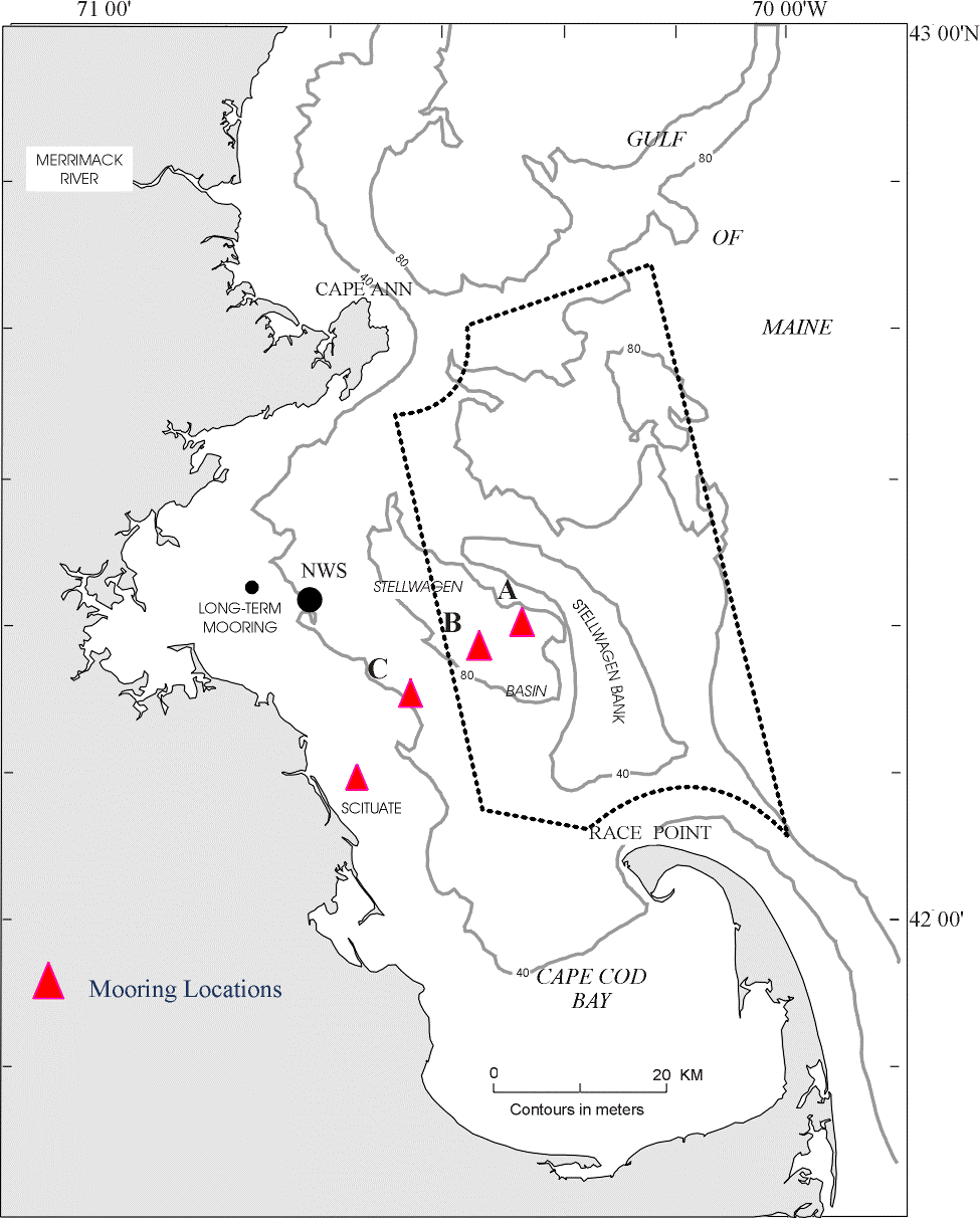
Figure 1: Instrumented moorings were deployed a four sites across Massachusetts Bay to investigate the internal waves that propagate westward from Stellwagen Bank each tidal cycle. A horizontal mooring, with insturments spaced about 30 m apart in the horizontal, was deployed at Site B.
The surficial sediment distribution (Figure 2) in Massachusetts Bay reflects the topography the processes which resuspend sediments, and the geologic history. Stellwagen Basin, the deepest part of Massachusetts Bay, is about 90 m deep and is floored with fine-grained mud. Along the western shore of Massachusetts Bay, the transition from mud to coarser sand, gravel and outcropping rock occurs at 40- 50 m water depth. Surface waves from winter storms, particularly waves generated from storms with winds from the northeast that enter Massachusetts Bay from the Gulf of Maine, are sufficiently to resuspend the bottom sediments in water depths shallower than 40 - 50 m. These waves winnow fine sediments that accumulate along the shallow western shore of Mass Bay, and the currents driven by the winds from the northeast carry the sediments southeastward toward Cape Cod Bay and offshore into Stellwagen Basin where they accumulate. Elevated levels of contaminants, introduced from the Boston Metropolitan region, are found in the sediments of Cape Cod Bay and Massachusetts Bay. The internal waves may cause resuspension and transport of these sediments and associated contaminants in summer. In addition, the dissipation of the internal waves may play a role in the transition of the sediment from fine to coarse along the western shore.
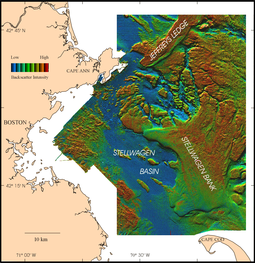
Figure 2: Sun-illuminated map of the coastal region to the east of Boston Massachusetts Bay, including the Stellwagen Bank National Marine Sanctuary. The backscatter intensity is draped over the topography. Red indicates high backscatter material (sand, gravel and rock); blue indicates low backscatter material (mud). Within each backscatter color, the intensity varies from dark to light depending on the sun illumination. The image illustrates shows a complex and wide variety of sedimentary environments. The transitions between sediment types is often very sharp. Topographic features observed here were formed for the most part by glacial processes. Ice containing rock debris moved across the region, sculpting its surface and depositing sediment to form basins, knoll, banks and other features. Stellwagen Bank and Jefferys Ledge are shallow banks (20-40 m water depth) covered with sand and gravel. Stellwagen Basin (80-100 m) is floored with mud. In winter, the sea floor is modified by storm currents and waves from the northeast. These currents erode sand and mud from the shallow banks and transport them into the basins. Currents associated with internal waves generated by Stellwagen Bank may resuspend the fine sediments in Stellwagen Basin, and winnow sediments from the western shore of the bay.
The summer 1998 experiment was carried out to address the following questions:
(1) Do the internal solitons cause resuspension of bottom sediments?
The maximum current speed reported by Trask and Briscoe (1983) during a 5-day experiment was about 60 cm/sec at 40 m depth. Near-bottom speeds of this amplitude would be expected to resuspend the muddy bottom sediments. Thus the solitons may be important in the transport of the contaminated sediments found in Stellwagen Basin. Transport and resuspension by the shoaling internal waves may also influence the location of the transition from fine to coarse sediments that is observed at about 50 m water depth along the western shore of Massachusetts Bay. The internal solitons may undergo rapid changes and dissipate at some point along the western shore of Massachusetts Bay.
(2) How do the wave packets evolve as they propagate inshore?
Previous field observations were carried out at a single location in the center of Massachusetts Bay and did not investigate how the waves change as they propagate inshore. Of particular interest what how the waves dissipate along the western shore.
(3) Do the waves follow the KdV non-linear dispersion relation?
The Korteweg-de Vries equation (Gear and Grimshaw,1983) describes to
first order the propagation of solitons in shallow water. However, Holloway
(1987) and others have found that they must employ second-order wave amplitude
wave theory to account for the observed wavelength and phase speed of solitons.
The horizontal mooring will allow for a direct measurement of phase speeds
and horizontal wavelengths and the nearby surface-subsurface mooring pair
will provide vertical mode structure and amplitudes of the waves. This
data will allow for a direct test of the dispersion relation derived from
the non-linear theory and determine if the second order theory is required
to accurately describe the waves.
Moored Array
The moored array consisted of instruments deployed at 4 stations spaced across Massachusetts Bay (Figure 1 and Figure 3). Station A , located about 5 km from the western edge of Stellwagen Bank at 95 m water depth, was placed to provide a description of the waves near the generation region. Station B was located approximately 12 km from the western edge of Stellwagen Bank in the center of Stellwagen Basin at 85 m water depth. Station B is near the location of previous observations of the internal solitons made by Halpern (1971) and Haury et al (1979). Site B was heavily instrumented from 10 m from the surface to 1 m above bottom with an array of temperature, conductivity, current, light transmission and pressure instruments deployed on 4 separate moorings. One of the moorings at the central site (B) was a horizontal mooring to provide closely spaced measurements in both the horizontal and vertical. Site C was located at 50 m water depth, just offshore of the transition from fine to coarse-grained sediments and included temperature, conductivity, current and light transmission. The inshore site was at 20 m water depth. In order to resolve the high-frequency motions caused by the internal waves, instruments in the array were set to sample every 15 s (for most temperature and conductivity observations), or every minute (for most current observations).
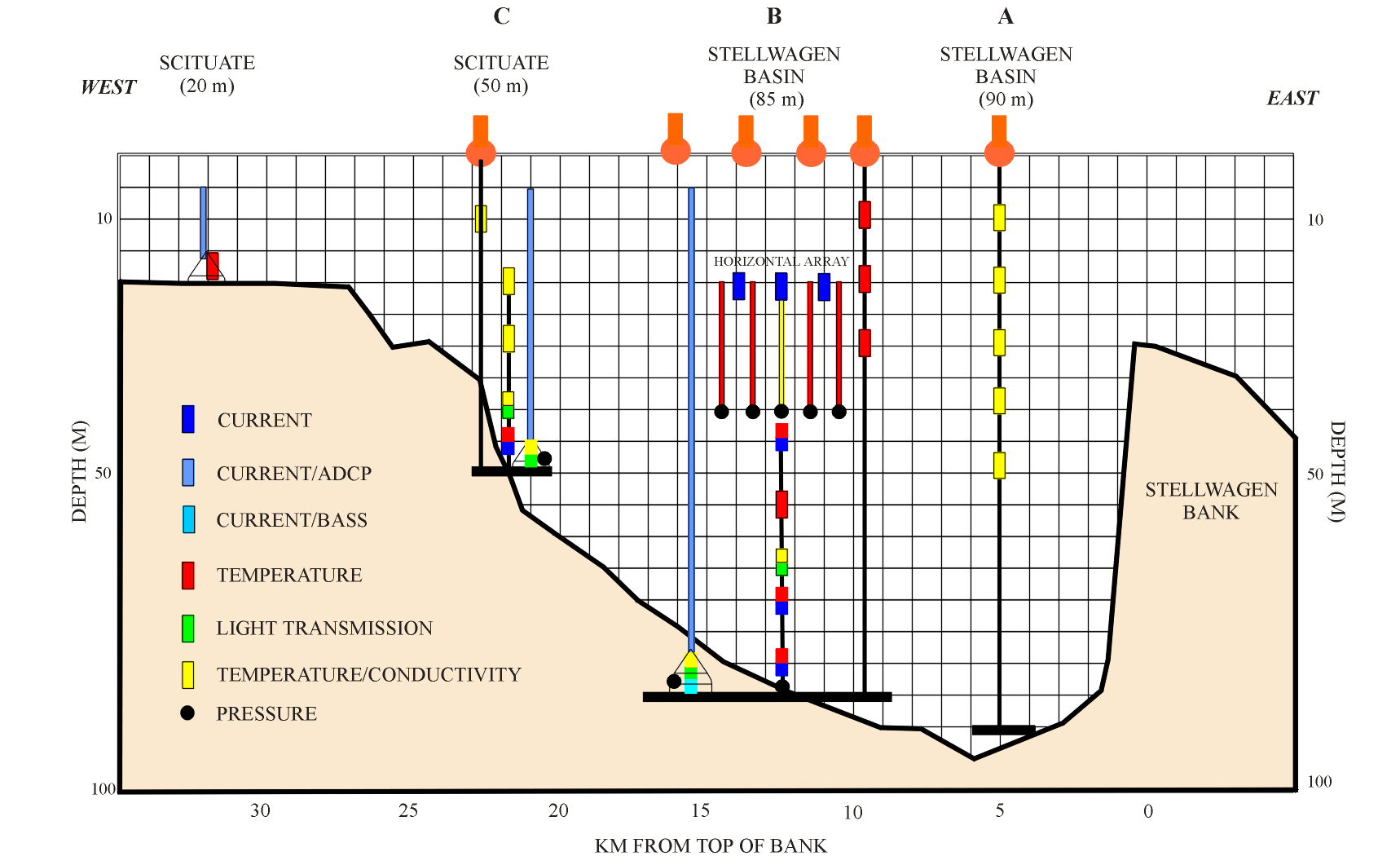
Figure 3: Instruments were deployed at four sites across Stellwagen Basin to observe the packets of internal solitons as the propagate westward across Massachusetts Bay from Stellwagen Bank. The horizontal array was deployed at site B.
The horizontal mooring deployed at Site B is a new technology, under development by WHOI in cooperation with ONR, designed to provide closely spaced (order 20 m) measurements in both the horizontal and vertical in the coastal ocean. The mooring consisted of a 160 m long horizontal wire tensioned between two 48" subsurface floats at 20 m below the surface. The floats are kept in position by anchors attached to each float and set at a 450 angle. Along the horizontal wire, 5 vertical wires spaced 30 m apart supported temperature and conductivity sensors 5 m apart in the vertical from 20 to 45 m water depth. In addition, three current meters were mounted on the horizontal wire, one at the center, and one at each end 55 m from the central meter.
Hydrography and water displacement observations
Single hydrographic sections (conductivity, temperature and light transmission) along the mooring line were obtained on August 6 and August 20 to provide a measurement of the water column structure along the mooring line. Fourteen stations were occupied along the mooring transect.
Scatterers on the thermocline and in the near-surface layer provide a marker of displacements in the water column that can be observed using a high frequency echo sounder. A 200 kHz echo sounder was used on the mooring deployment cruise to monitor the excursions of the thermocline at the central site. In addition, several sections were made between the 40 and 70 m at Site C to document the internal wave amplitude and structure as the propagate into shallow water.
Modeling
Numerical modeling is focused on both the generation mechanism (lee
wave hypothesis) and the evolution of the wave packet as it moves onshore.
In particular, we plan to focus on the following questions: Why do waves
seem to develop only on the inshore site of the bank? Is the process influenced
by the different bottom slope on either side of the bank? What are the
factors influencing the splitting and ordering of the wave packet? What
does the current field look like near the bottom (which is important for
the resuspension problem)? To answer these questions we plan to solve the
2D Navier-Stokes equations for a stratified fluid in vorticity-streamfunction
formulation, with a realistic bottom topography.
During the deployment cruise the weather was exceedingly calm, and bands of smooth and ruffled water, surface expressions of the internal wave packets, were clearly visible. Sometimes the slicks were observed in intersecting patterns, suggesting wave packets from different generation regions. Undulation of the thermocline caused by the high-frequency waves were clearly observed at Site B by the 200 Khz echo sounder. One of the observations of Halpern (1971) was that the waves were rank ordered, with the largest amplitude wave the first to arrive. On August 6 however, the 200 kHz record shows larger waves arriving later in the packet. The sections across the hypothesized dissipation region near Site C showed modification in amplitude and pattern as the waves moved into shallow water. Undulations of the thermocline were observed to water depths of 30 m with the 200 Khz echosounder. Time did not permit following the waves further inshore.
ACKNOWLEDGEMENTS
This work was supported by the Office of Naval Research and the U.S. Geological Survey.