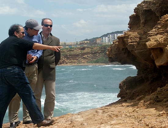
 Senior Scientist Jian Lin (blue shirt) and colleagues examine geological evidence of past earthquakes near the Mediterranean coast of Algeria. A study of the interplay of stresses surrounding a magnitude 6.9 earthquake in Algeria has given Lin and other scientists new insight into the evolution of this type of quake. Lin, a geophysicist, reports a “strong earthquake interaction” between offsetting thrust faults called en echelon faults and adjacent tear faults in the 2003 Zemmouri quake off Algiers. “We…illustrate that strong earthquake interaction between thrust ruptures and adjacent tear faults is an essential feature of contractional tectonics,” says Lin. “Thus, such stress interaction must be considered in assessing earthquake potentials in contractional regions of the world, such as northern Algeria, central California and the Los Angeles Basin.” Lin's work in Algeria has been funded by the Office of Foreign Disaster Assistance at the U.S. Agency for International Development. (Photo courtesy of Jian Lin, Woods Hole Oceanographic Institution)
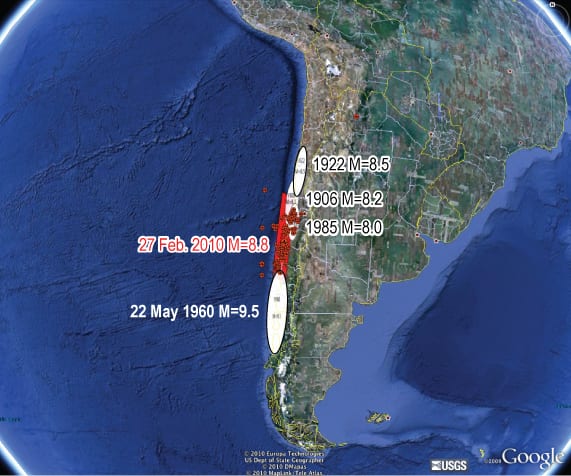 The February 2007 earthquake off the coast of Chile occurred just north of a 1960 rupture. The earlier quake had had caused stress to build elsewhere along the fault line. (Volkan Sevilgen, US Geological Survey; Jian Lin, Woods Hole Oceanographic Institution; and Ross Stein, US Geological Survey)
 A WHOI “D2” ocean-bottom seismograph is field-tested on the seafloor near the TAG hydrothermal vent site in the North Atlantic. The seismometer is housed in the silver canister at right; a weight anchors it to the bottom. The instrument records details of earthquakes on the seafloor for up to a year, including very faint tremors that are difficult to detect and analyze from shore. (Photo by Rob Reves-Sohn, Woods Hole Oceanographic Institution)
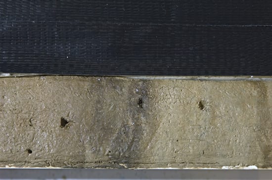
 A record of past tsunamis may be preserved in seafloor sediments as layers of fine-grained particles that are stirred up by tsunami-generating seafloor earthquakes and later resettle on the seafloor. (Photo by Tom Kleindinst, Woods Hole Oceanographic Institution)
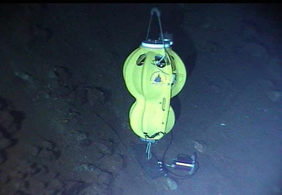
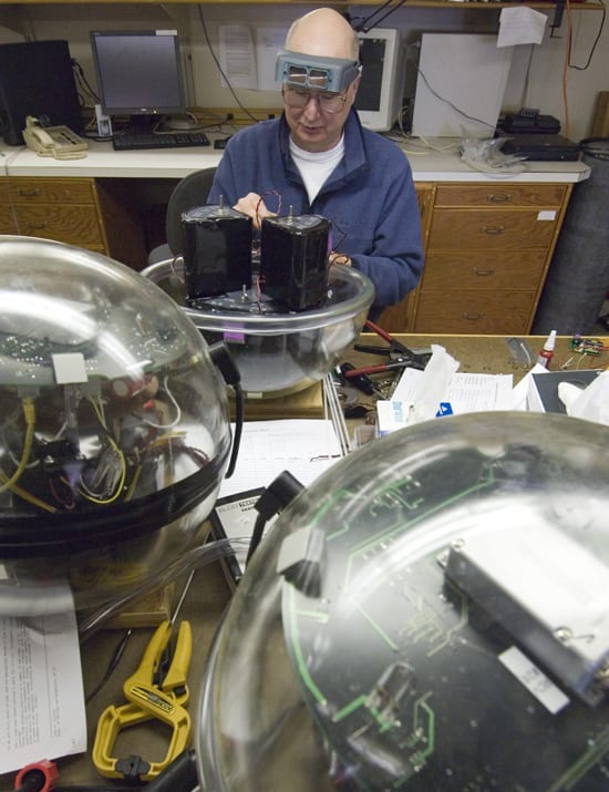
 The WHOI “D2” ocean-bottom seismometer's electronic data logger, which records seismic wave measurements for up to a year on the seafloor, is housed in a glass ball in one half of the peanut-shaped instrument. Batteries are in the other half. (Photo by Victor Bender, Woods Hole Oceanographic Institution)
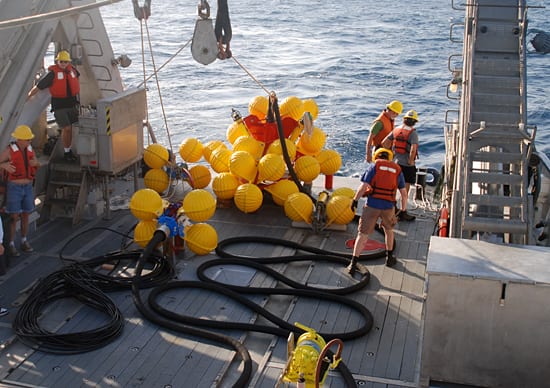
 Engineering assistant Rob Handy handles a line during recovery of an ocean bottom seismometer (OBS) aboard R/V Atlantis in January 2009. The OBS was just one of 41 deployed along the Quebrada, Discovery, and Gofar transform faults at the East Pacific Rise, that had been recording earthquakes for the past year. This area is known to have large earthquakes—greater than magnitude 5. Hundreds of earthquakes occur every day around the world, most of them underneath the oceans, while the vast majority of instruments used to record earthquakes are on land. As a result, advances in understanding basic earthquake processes have been limited by the available data. Chief scientist Jeff McGuire and his colleagues are using the instruments—deployed at depths of 2500-4200 meters—to gain a better understanding of earthquakes. (Photo by Jeff McGuire, Woods Hole Oceanographic Institution)
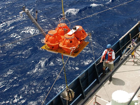
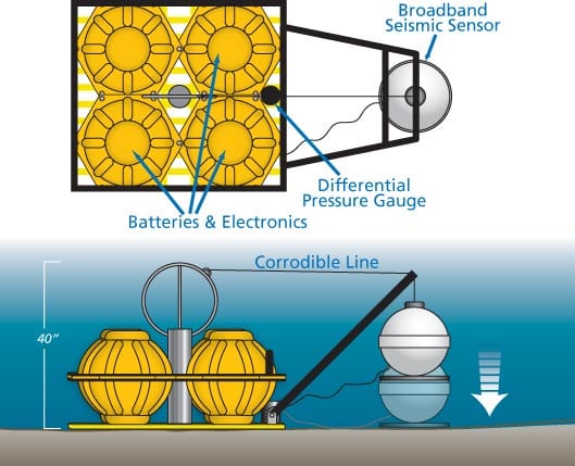
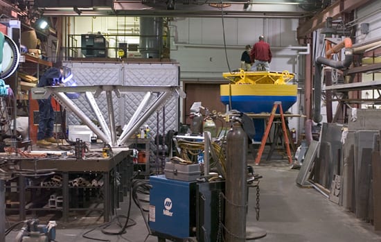
 WHOI is designing and building new-generation ocean-bottom seismometers (OBSs) for long-term deployments that last more than a year. The four orange fiberglass “hardhats,” mounted on a plastic grillwork, contain batteries and electronics. A differential pressure gauge measures earthquake-generated waves in the water. The seismometer is housed in a metal sphere attached to an swivel at right. When the OBS is deployed, a metal line corrodes, releasing the seismometer to rest on the seafloor. (Illustration by Jack Cook, Woods Hole Oceanographic Institution)
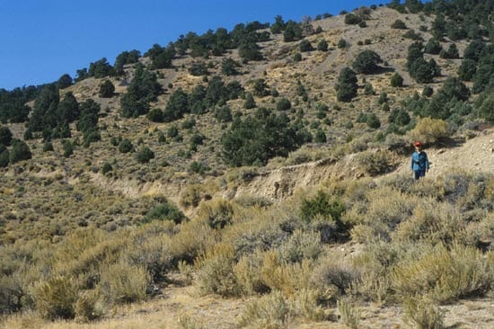
 WHOI geophysicist Jian Lin stands near the plainly visible ruptured surface of the Pleasant Valley Fault in Nevada, which caused a magnitude 7.1 earthquake in 1954. (Photo courtesy of G. Valensis/Italian Institute of Seismology)
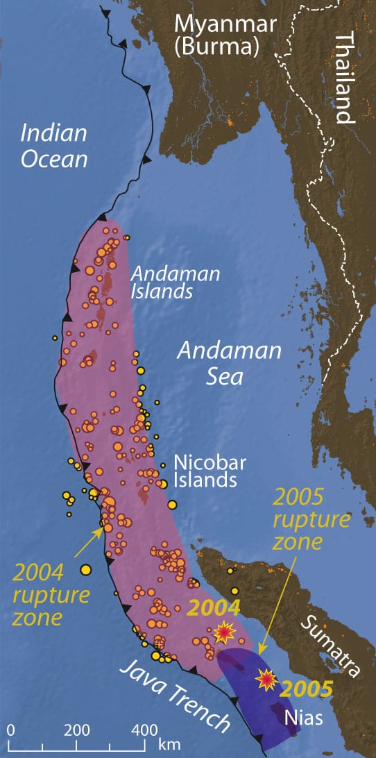
 A March 28, 2005, earthquake in the eastern Indian Ocean occurred to the south of the larger December 2004 earthquake, supporting the theory that the later earthquake may have been triggered by the 2004 event. Such stress triggering behavior is very similar to a sequence of thrust earthquakes that occurred in central California in the 1980s. The small yellow circles in the pink rupture zone, which is many times larger than the 2005 rupture zone shown in blue, represent aftershocks within the first three weeks after the Dec. 26 earthquake. The data were provided by the U.S. Geological Survey. (Illustration by Jack Cook, Woods Hole Oceanographic Institution)
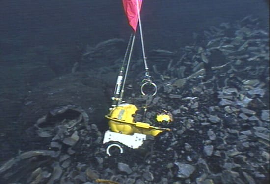
 An eruption that covered 9 square miles of seafloor with fresh lava at the East Pacific Rise also trapped three ocean-bottom seismometers. Scientsts successfully recovered two of them with the remotely operated vehicle Jason in April 2007. (Photo courtesy of the National Deep Submergence Facility, ROV Jason, Woods Hole Oceanographic Institution, and the National Science Foundation)
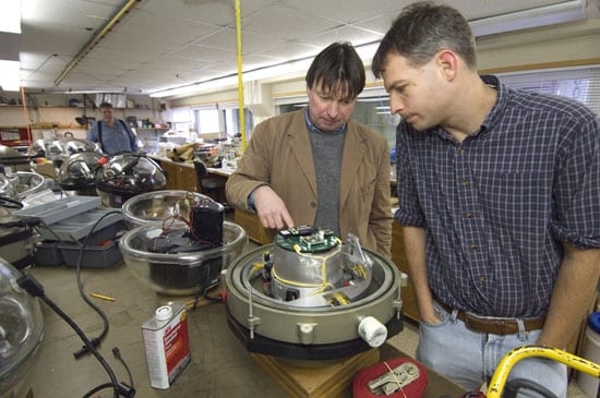
- WHOI seismologists John Collins (left) and Jeff McGuire check an electronic data logger, which records seismic wave measurements, in the Ocean Bottom Seismometer Lab. (Photo by Tom Kleindinst, Woods Hole Oceanographic Institution)
 On May 6, 2007, WHOI researchers and technicians deployed the Real Time Offshore Seismic Station (RTOSS) off the coast of Grenada. RTOSS is part of a project to develop new mooring technology for earthquake monitoring, and it includes an ocean-bottom seismometer deployed directly on top of the volcano to collect real-time data from the hazardous Kick‘em Jenny volcano. The new system should significantly improve the ability of natural hazard managers to notify and protect the island’s residents from volcanic eruptions and tsunamis. (Photo by Robert Reves-Sohn, Woods Hole Oceanographic Institution)
 WHOI engineer Warren Witzell assembles a “D2” ocean-bottom seismograph (OBS), available to earthquake researchers through the U.S. National Ocean Bottom Seismograph Instrument Pool partly administered by WHOI. (Photo by Tom Kleindinst, Woods Hole Oceanographic Institution)
 Michael McCarthy (black shirt) of WHOI's Operational Scientific Services and Neil McPhee (red shirt) of the Instrument Systems Development Lab stand atop a new tsunami and earthquake monitoring buoy being built using WHOI's new "gumby mooring" design. At the same time, welder Geoff Ekblaw (left) works on the framework for another piece of gear. (Photo by Tom Kleindinst, Woods Hole Oceanographic Institution)
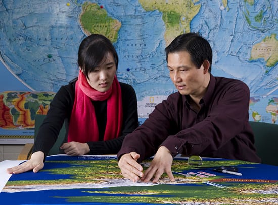
 WHOI guest student Tingting Wang and senior scientist Jian Lin (right) study Haiti earthquake data on charts. Lin has studied Haiti and other tectonic areas of the Caribbean and has served as a science source for newspaper, radio and television coverage of that quake, as well as subsequent earthquakes in Chile and China. He cautions that future quakes in Haiti could strike a segment of the Enriquillo Fault very close to the capital city and urges rebuilding of emergency government structures in safer areas outside of Port-au-Prince. Lin also studies a major zones in Algeria and elsewhere around the world (Photo by Tom Kleindinst, Woods Hole Oceanographic Institution)
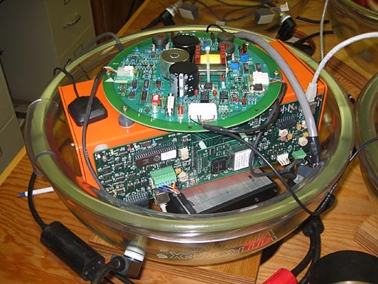
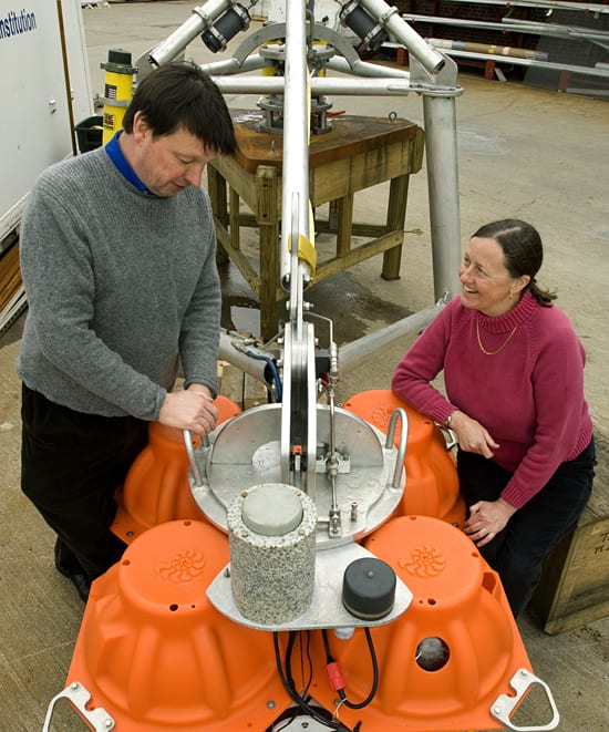
 Geology and Geophysics research specialist John Collins and geologist Susan Humphris discuss the Broadband Ocean Bottom Seismograph, or BBOBS. Associate Scientist Jeff McGuire and Collins were the recipients of a major grant from the W.M. Keck Foundation to investigate earthquake predictability. The project will capitalize on their earlier discovery that earthquake foreshocks routinely occur before mainshocks on some oceanic faults, suggesting that short-term prediction may be feasible under certain circumstances. (Photo by Tom Kledindinst, Woods Hole Oceanographic Institution)
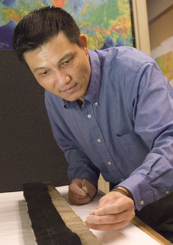
SEARCH RELATED TOPICS: Earthquakes
Image and Visual Licensing
WHOI copyright digital assets (stills and video) on this website can be licensed for non-commercial use upon request and approval. Please submit your request via our Media Request Form.
For assistance or accessibility accommodations, call (508) 289-2647.