
FAQ: Malaysia Airlines Flight 370
March 18, 2014
MEMBERS OF THE NEWS MEDIA, PLEASE NOTE: The Woods Hole Oceanographic Institution has offered its expertise to the authorities responsible for the search for MH370. At this time, WHOI is not involved in the search. Until more information is available, we are limiting media interviews to those already booked.
The fate of Malaysia Airlines flight 370 remains a mystery. Because the search for the airliner has involved searching the ocean, many have turned to those involved in the search for Air France flight 447 to learn from their experiences in that case and their expertise in detecting objects on the seafloor.
Woods Hole Oceanographic Institution Director of Special Projects David Gallo and Principal Engineer Mike Purcell co-led the search that found the missing aircraft, Air France 447 in 2011. The search team deployed unmanned underwater vehicles to scan the 2.5-mile deep and rocky underwater terrain off Brazil’s northeast coast and located the wreck site two years after the plane disappeared.
Dr. Gallo and Mr. Purcell share their insight from the Air France 447 search and comment on the Malaysia Airlines Flight 370 (MH370).
How does Malaysia Airlines Flight 370 (MH370) compare to the Air France 447 search operation?
GALLO: During the Air France 447 search, the area was very remote, the sea very deep, and the seafloor was very rugged and mountainous. The search area was as deep as 4,000 meters and spread out over 5,000 square miles.
The potential MH370 search area is much larger and it must be reduced prior to starting any underwater search. The Indian Ocean seafloor is varied so it is possible that the terrain would be similar to the Air France 447 search.
How different is the southern Indian Ocean from the Atlantic Ocean?
GALLO: Topographically they are relatively similar. A 50,000-mile-long chain of underwater mountains with steep slopes and deep valleys called the Mid-Ocean Ridge runs through both oceans. At that depth, the ocean is pitch black, so the search would rely on the use of sonar. The southeast Indian Ridge ranges from about 2,500-4,000 meters deep. The bottom is comprised of hard volcanic rock.
However, the southern Indian Ocean has some of the roughest seas in the world, which can prolong any search operation at sea.
PURCELL: The Indian Ocean’s surface conditions would be an added challenge for any autonomous underwater vehicle (AUV) launch and recovery, and possibly for towed sonar systems. While we did not have to suspend operations during the AF447 search because of weather, it would be more likely to happen in the southern Indian Ocean where the weather can be more severe.
How would debris help lead you back to the potential wreck site?
PURCELL: After debris from the plane is located in the water or on a beach, the next step would be to project where it came from. This involves modeling the wind, waves, and currents and estimating how the located objects would drift in these conditions. The longer it takes to locate the debris, the harder it becomes to accurately project the accident location and thus the search area increases.
GALLO: Once debris is located, and ideally the aircraft’s Last Known Position (LKP) identified, scientists can back track where the debris came from by using sophisticated computer models. Wind on the sea surface and ocean currents below play significant roles in determining where and how debris will move in the ocean.
These models can estimate the debris path over the last 16 days fairly accurately. However, the more time passes without any debris found, the margin of error in the models widens.
What does a search at sea entail?
PURCELL: A search area location far from shore requires good planning. Because it can takes days to reach the search zone by ship, once you are at sea, you have to work with what you have brought with you. An underwater search is slow compared to a surface search for debris using many planes and ships. By contrast, the autonomous underwater vehicles (AUVs) or towed systems move much slower and the acoustic sensors (sonar) can see much shorter distances than radar systems used on planes.
It also depends on where the wreckage settles. In areas with a flat seafloor, it is relatively easy to identify the wreckage in the acoustic data. If it has settled in an area with rough terrain, it can be more difficult. Typically, potential sites first are identified from the sonar data and then pictures are taken to confirm if the target is the wreckage.
In the case of MH370, is the length of this search typical or expected?
GALLO: This is an extremely unusual case, because there has been no confirmed evidence of the plane at all.
PURCELL: The search is complicated by the fact the plane flew for a long time without transmitting its position. This has created a huge initial search area.
What do you think we can learn from the search for Air France 447?
PURCELL: From my viewpoint, we learned many things about conducting an underwater search that could be useful if such a search is required for MH370. Perhaps it is more important to understand that it took almost two years to locate the wreckage from the Air France accident. Determining what happened, deciding where to look, and then looking, can take a long time.
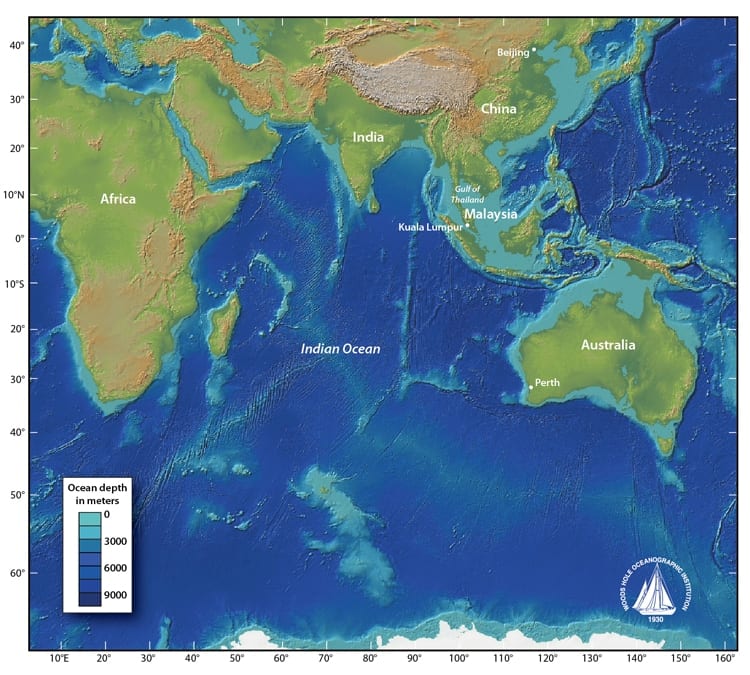
The Indian Ocean spans about 73.6 million square kilometers (28.4 million square miles). With mid-ocean ridges, deep ocean trenches, strong winds, and currents, it is a large and complex body of water to search and navigate. The deepest point of the Indian Ocean is the Diamantina Trench, which drops to 8,047 meters, or over 5 miles deep. (Map courtesy of Jack Cook, Graphic Services Group, Woods Hole Oceanographic Institution)
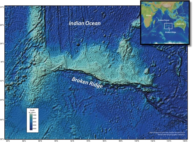
Southern Indian Ocean volcanic plateau, Broken Ridge, ranges from 800 to 3,000 meters deep. (Map courtesy of Jack Cook, Graphic Services Group, Woods Hole Oceanographic Institution)
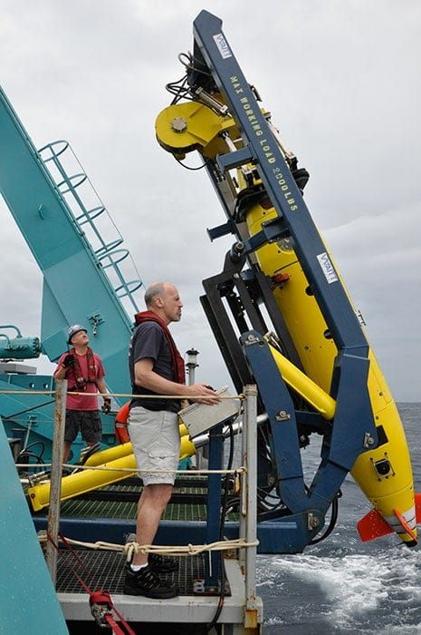
Principal engineer Mike Purcell deploys an unmanned underwater vehicle developed at Woods Hole Oceanographic Institution - the REMUS 6000 - to search for the Air France 447 aircraft. Purcell and his team successfully located the airplane crash site in 2011, two years after the plane went missing. (Photo courtesy of Woods Hole Oceanographic Institution)

David Gallo, director of special projects, co-led the Woods Hole Oceanographic Institution team that searched and discovered the missing Air France 447 plane off the coast of Brazil. (Photo courtesy of Woods Hole Oceanographic Institution)
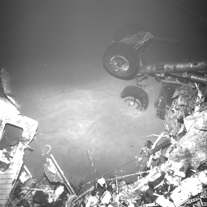
Air France flight 447 from Rio de Janeiro to Paris crashed several hundred miles off the northeastern coast of Brazil. On April 4, 2011, a search team led by the Woods Hole Oceanographic Institution (WHOI) located the wreckage of the Airbus jet some 3,900 meters (nearly 2.5 miles) below the surface of the Atlantic Ocean.