
Interactions between a marine heatwave and tropical cyclone Amphan in the Bay of Bengal in 2020
Rathore, S., Goyal, R., Jangir, B., Ummenhofer, C., Feng, M., & Mishra, M. (2022). Interactions between a marine heatwave and tropical cyclone Amphan in the Bay of Bengal in 2020. Frontiers in Climate, 4, 861477. https://doi.org/10.3389/fclim.2022.861477
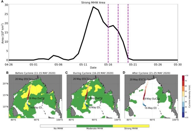
(A) Ocean surface area of the Bay of Bengal covered by strong MHW conditions with vertical magenta lines representing cyclogenesis (left), cyclone intensification (middle) and landfall (right) for tropical cyclone Amphan, (B–D) categories of marine heatwave over the Bay of Bengal before tropical cyclone Amphan (averaged over 11–15 May 2020), during the cyclone (averaged over 16–20 May 2020) and after the cyclone (averaged over 21–25 May 2020) overlaid by the track of the cyclone which is shaded by the mean daily intensity of the cyclone (m s−1) with the date of cyclogenesis (CS, 16-May-2020), date of super cyclonic storm (SuCS, 18-May-2020) and landfall as extremely severe cyclonic storm (ESCS 20-May-2020). Figure taken from Rathore et al. (2022).
Rathore et al. (2022) investigates the interaction between a marine heatwave (MHW) and tropical cyclone Amphan in the Bay of Bengal in May-2020. The Bay of Bengal exhibits high sea surface temperatures (~28 C) and strong stratification and consequently is particularly prone to tropical cyclones, accounting for 5-7% of the total number of tropical cyclones globally. Strong MHW conditions occurred in the Bay of Bengal in spring 2020 prior to the formation of cyclone Amphan. Previous studies have shown an unusual rapid intensification of the tropical cyclone Amphan from category 1 (cyclonic storm) to category 5 (super cyclone) in less than 24 hours.
The study infers that the rapid intensification of Amphan into a super cyclonic storm is primarily due to the presence of a strong MHW underneath the track of the cyclone. The generation of the MHW was due to coupled ocean-atmosphere processes which included shoaling of the mixed layer depth due to reduced wind speed, increased net surface shortwave radiation flux into the ocean, temperature generated upper ocean stratification, and increased subsurface warming (tropical cyclone heat potential). As the cyclone approached landfall, the intense wind-induced mixing deepened the mixed layer, cooled the sea surface temperature leading to the demise of the MHW, along with reduced tropical cyclone heat potential. The study brings a new perspective to understanding the risk of compound extreme events emerging from climate change that have severe socio-economic consequences in the affected countries.