
Image
Mowing the lawn
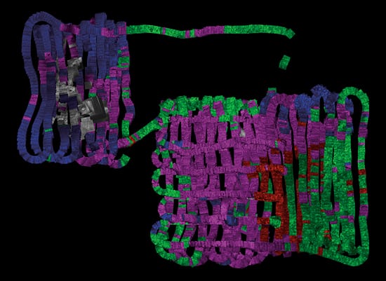
January 25, 2010The WHOI-operated deep-sea vehicle ABE systematically tracked over the seafloor on the volcanic Mid-Atlantic Ridge, midway between Africa and South America, photographing the ocean bottom. Some 3,000 overlapping photos were made into this photomosaic, encompassing an area of roughly 15.4 acres or 6.25 hectares. Working with WHOI volcanologist Adam Soule, summer student fellow Garrett Mitchell color-coded the map according to seafloor features. Blue=sheet lava; green=lobate lava flows; red=pillow lavas; purple=jumbled formations; gray=areas affected by hydrothermal vents.(Photomosaic by S. Adam Soule and Garrett Mitchell, Woods Hole Oceanographic Institution)
Image and Visual Licensing
WHOI copyright digital assets (stills and video) contained on this website can be licensed for non-commercial use upon request and approval. Please contact WHOI Digital Assets at images@whoi.edu or (508) 289-2647.