
Feature
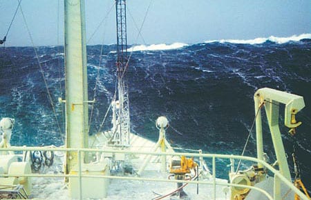
Deploying the Rain Catchers
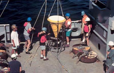
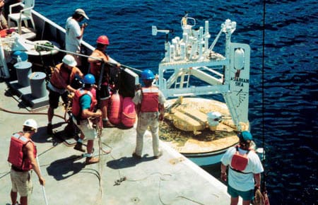
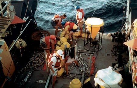
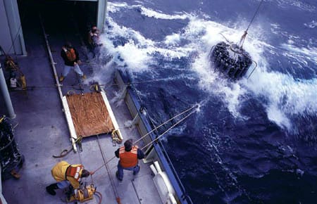
Deployment of a deep-ocean sediment trap mooring begins with the ship heading slowly into the wind.
Read MoreMonsoon Winds and Carbon Cycles in the Arabian Sea
The monsoon, a giant sea breeze between the Asian massif and the Indian Ocean, is one of the most significant natural phenomena that influences the everyday life of more than 60 percent of the world’s population.
Read MoreA New Way to Catch the Rain
The carbon budget of the upper ocean includes an important loss to the deep ocean due to a very slowly falling rain of organic particles, usually called sediment. As this sediment falls through the upper water column it is consumed, mainly by bacteria, and the carbon is recycled into nonsinking forms (dissolved or colloidal organic carbon or inorganic forms). Thus the sediment rain decreases with increasing depth in the water column, and only a tiny fraction reaches the deep sea floor, less than about one percent.
Read MoreContinental Margin Particle Flux
The boundaries between the oceans and the continents are dynamic regions for the production, recycling, and deposition of sedimentary particles. In general, rates of biological productivity along continental margins are significantly higher than in the open ocean. This is due to a variety of factors including coastal upwelling of nutrient-rich waters and nutrient input from continental runoff. While continental margins account for only about 10 percent of the global ocean area, 50 percent of the total marine organic carbon production is estimated to occur in this limited region, with much of it exported to the deep sea.
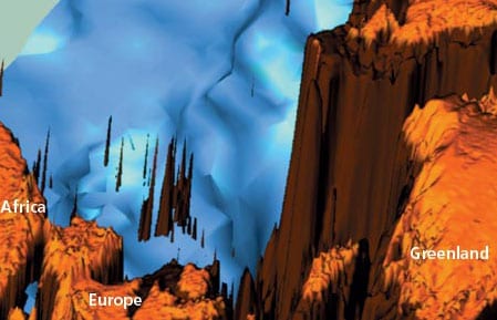
Read MoreGeochemical Archives Encoded in Deep-Sea Sediments Offer Clues for Reconstructing the Ocean’s Role in Past Climatic Changes
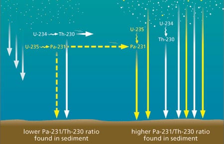
Geochemical Archives Encoded in Deep-Sea Sediments Offer Clues for Reconstructing the Ocean’s Role in Past Climatic Changes
Paleoceanographers are trying to understand the causes and consequences of global climate changes that have occurred in the geological past. One impetus for gaining a better understanding of the factors that have affected global climate in the past is the need to improve our predictive capabilities for future climate changes, possibly induced by the rise of anthropogenic carbon dioxide (CO2) in the atmosphere.
Ground-Truthing the Paleoclimate Record
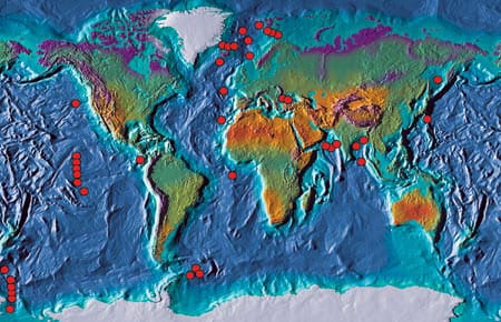
Sediment Trap Observations Aid Paleoceanographers
The geological record contains a wealth of information about Earth’s past environmental conditions. During its long geological history the planet has experienced changes in climate that are much larger than those recorded during human history; these environmental conditions range from periods when large ice sheets covered much of the northern hemisphere, as recently as 20,000 years ago, to past atmospheric concentrations of greenhouse gases that warmed Earth’s polar regions enough to melt all of the ice caps 50 million years ago. Since human civilization has developed during a fairly short period of unusually mild and stable climate, humans have yet to experience the full range of variability that the planet’s natural systems impose. Thus, the geological record has become an extremely important archive for understanding the range of natural variability in climate, the processes that cause climate change on decadal and longer time scales, and the background variability from which greenhouse warming must be detected
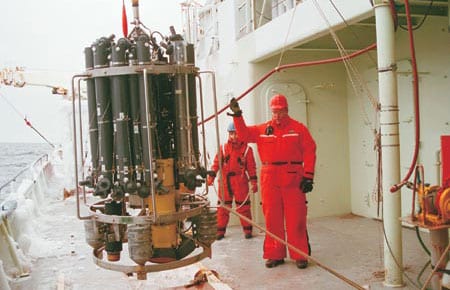
Catching the Rain: Sediment Trap Technology
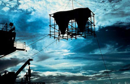
WHOI Senior Engineer Ken Doherty developed the first sediment trap in the late 1970s for what has come to be known as the WHOI PARFLUX (for “particle flux”) group. Working closely with the scientific community, Doherty has continued to improve sediment traps for two decades, and these WHOI-developed instruments are widely used both nationally and internationally in the particle flux research community.
Read MoreReplacing the Fleet
When R/V Atlantis arrived in Woods Hole for the first time on a bright, beautiful April 1997 day, it represented not only a welcome addition to the WHOI fleet but also the culmination of a 15-year UNOLS fleet modernization.
Read MoreWHOI and Access to the Sea
In the mid-term future, two WHOI ships (Knorr in about 2006 and Oceanus in about 2009) will reach the end of their planned service lives. There is general agreement that WHOI should work to replace them with two vessels.
Read MoreA Northern Winter
As the 1996-1997 ship schedule began to take shape in 1995, we learned that Voyage 147 would take R/V Knorr into the North Atlantic from October ’96 through March of ’97. The various science missions would require station keeping during CTD casts, deployment of current drifters, and expendable bathythermograph (XBT) launches, as well as weather system analysis designed to put Knorr in the path of the harshest weather conditions possible during the winter season. Long before the cruise, we began to tap all available assets that would help us with this challenge.
Read MoreAdventure in the Labrador Sea
The sound of the general alarm bell reverberated through the ship. At 2:30 AM, this couldn’t be a drill. Even more puzzling, we were still dockside in Halifax, four hours from our scheduled departure for the Labrador Sea.
Read More“What a Year!”
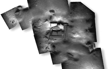
Four technologies that have been developing separately for some time were brought together this year by WHOI’s Deep Submergence Laboratory (DSL) to serve three very different user communities. With images from the towed vehicle Argo II and the remotely operated vehicle Jason, DSL scientists and engineers created mosaic images of a sunken British cargo ship and 20-meter-tall hydrothermal vent chimneys, both in the Pacific Ocean, and ancient shipwreck sites in the Mediterranean. The three expeditions thus served the marine safety, scientific, and archaeological communities.
Read MoreAccess to the Sea
Oceanographic fieldwork has traditionally meant going to sea on a ship. In recent years, it has expanded to include activities that may require a ship for a short period but then continue independently. Floats that drift with ocean currents, periodically reporting their positions via satellite, for example, are generally launched from ships but do most of their work independently. Long-term seafloor observatories may need ships to set them up and service them occasionally, but, again, they are designed to collect data for long periods without needing a ship. We have come to think of the body of ways oceanographers glean information from the ocean as “access to the sea,” and so that is the topic for this issue of Oceanus.
Read MoreThe Magnetic Thickness of a Recent Submarine Lava Flow
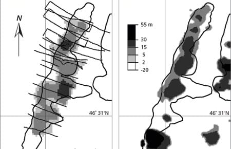
Submarine lava flows and their associated narrow feeder conduits known as dikes constitute the basic building blocks of the upper part of the ocean crust. We are only beginning to understand how lava erupts and forms on the seafloor by flooding topographic lows, flowing through channels or tubes, centralizing into volcanoes, or some combination of all of these.
Read MoreNew Data on Deep Sea Turbulence Shed Light on Vertical Mixing
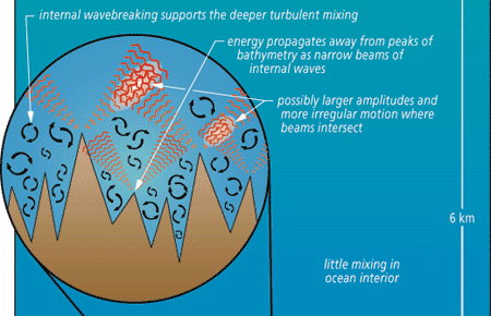
The global thermohaline circulation is basically a wholesale vertical overturning of the sea, driven by heating and cooling, precipitation and evaporation.
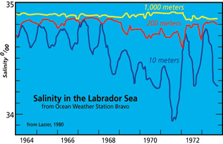
Read MoreLabrador Sea Water Carries Northern Climate Signal South
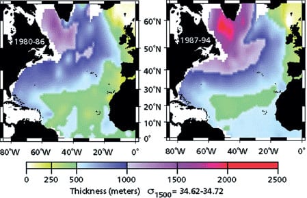
Changes in wind strength, humidity, and temperature over the ocean affect rates of evaporation, precipitation, and heat transfer between ocean and air. Long-term atmospheric climate change signals are imprinted onto the sea surface layer, a thin skin atop an enormous reservoirA? and subsequently communicated to the deeper water masses. Labrador Sea Water is a subpolar water mass shaped by air-sea exchanges in the North Atlantic. It is a major contributor to the deep water of the Atlantic, and changes of conditions in its formation area can be read several years later at mid-depths in the subtropics. Mapping these changes through time is helping us to understand the causes of significant warming and cooling patterns we have observed at these depths in the North Atlantic and links the subtropical deep signals back to the subpolar sea surface conditions.
Read MoreNorth Atlantic’s Transformation Pipeline Chills and Redistributes Subtropical Water
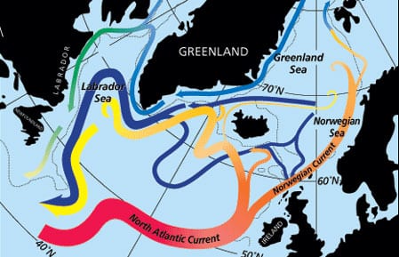
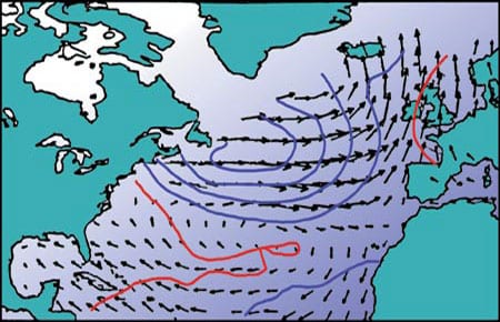
Warm and salty waters from the upper part of the South Atlantic flow northward across the equator and then progress through the tropical and subtropical North Atlantic to reach high latitudes. Beginning with the intense northward flow of the Gulf Stream off the East Coast of the United States, these waters are exposed to vigorous cooling, liberating considerable oceanic heat to the atmosphere. This is the first stage of “warm water transformation within the North Atlantic, a process that culminates in the high latitude production of cold and fresh waters that return to the South Atlantic in deep reaching currents beneath the warm waters of the subtropics and tropics.
Read MoreIf Rain Falls on the OceanDoes It Make a Sound?
As with similar questions about a tree in the forest or a grain of sand on the beach, it may be hard to imagine that a few inches of rain matters to the deep ocean.
Read MoreAlpha, Bravo, Charlie…
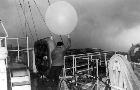
The ocean weather station idea originated in the early days of radio communications and trans-oceanic aviation. As early as 1921, the Director of the French Meteorological Service proposed establishing a stationary weather observing ship in the North Atlantic to benefit merchant shipping and the anticipated inauguration of trans-Atlantic air service. Up to then, temporary stations had been set up for special purposes such as the US Navy NC-4 trans-Atlantic flight in 1919 and the ill-fated Amelia Earhart Pacific flight in 1937.
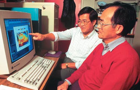
Read MoreComputer Modelers Stimulate Real and Potential Climate, Work Toward Prediction
Although weather forecasting is accepted by the public as part of daily life, oceanic forecasting is not yet so advanced. There are, however, successful examples of oceanic forecasting—one is the newly developed skill to predict El Nino/Southern Oscillation (ENSO) events, largely due to improvements in ocean modeling.
Read MoreA Century of North Atlantic Data Indicates Interdecadal Change
For hundreds of years mariners have recorded the weather over the world ocean. Some 100 million marine weather reports have accumulated worldwide since 1854, when an international system for the collection of meteorogical data over the oceans was established. These reports include measurements of sea surface temperature, air temperature, wind, cloudiness, and barometric pressure. In the 1980s, the National Oceanic and Atmospheric Administration (NOAA) compiled these weather observations into a single, easily accessible digital archive called the Comprehensive Ocean-Atmosphere Data Set. This important data set forms the basis for our empirical knowledge of the surface climate and its variability over the world’s oceans: One example of a variable system is the phenomenon known as El Nino in the tropical Pacific. A major challenge in climate research is to use these data to document and understand the role of the oceans in long-term—decadal and centennial—climate change.
Read MoreOceans & Climate
The past decade has brought rapid scientific progress in understanding the role of the ocean in climate and climate change. The ocean is involved in the climate system primarily because it stores heat, water, and carbon dioxide, moves them around on the earth, and exchanges these and other elements with the atmosphere.
Read MoreSedimentary Record Yields Several Centuries of Data
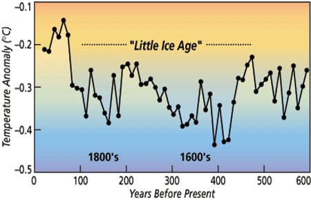
Natural climate changes like the Little Ice Age and the Medieval Warm Period are of interest for a few reasons. First, they occur on decade to century time scales, a gray zone in the spectrum of climate change. Accurate instrumental data do not extend back far enough to document the beginning of these events, and historical data are often of questionable accuracy and are not widespread geographically.
Read MoreTransient Tracers Track Ocean Cimate Signals
Transient tracers provide us with a unique opportunity to visualize the effects of the changing climate on the ocean. They trace the pathways climate anomalies follow as they enter and move through the ocean and give us valuable information about rates of movement and amounts of dilution. This knowledge is important for developing ocean-climate models to predict long term climate changes.
Read More