
WHOI oceanographers investigate southern Brazil’s catastrophic flooding
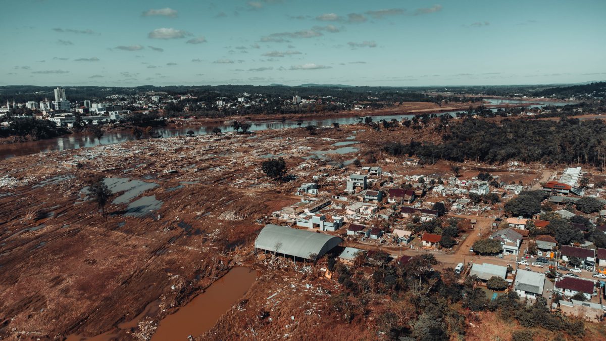 In May 2024, Rio Grande do Sul, Brazil’s fifth most populous state, was hit with unprecedented rainfall, affecting 2.3 million people. (Photo by: William Fernando Marx Purper/istock)
 March 31, 2025
Images available for use with credit can be found here.
Woods Hole, Mass. (March 31, 2025) – Devastating floods reshaped southern Brazil’s landscape in May 2024. Rio Grande do Sul - the fifth most populous state in Brazil - was hit with unprecedented rainfall, affecting 2.3 million people. A new study led by the Woods Hole Oceanographic Institution (WHOI) uses satellite data to help uncover what caused the deluges and examine how it impacted some of the state’s most vulnerable residents.
The study used data from NASA’s Surface Water and Ocean Topography (SWOT) satellite system in conjunction with topographical information to accurately assess the flood’s scope and volume. Unlike optical satellites, SWOT’s ability to provide data for areas under heavy cloud cover makes it a unique tool for effectively observing flood events. In this case, it measured the height of the water during peak flooding.
“This is the first time we had the opportunity to measure both the extent and volume of floodwater by satellite, providing a valuable tool for assessing flood impacts—especially in remote areas where local data is scarce or unavailable,” said WHOI Physical Oceanographer Iury Simoes-Sousa, lead author of the paper, who is from Brazil. “The estimated floodwater volume in Rio Grande do Sul was 1.5 billion cubic meters, enough to supply water to New York City for more than a year. That’s more than twice as much as previously seen during any extreme event in the region. Communities need to understand these events so that they can rebuild and design infrastructure in a way that can help protect against future extreme events.”
The study shows the state was caught between several atmospheric anomalies, forming what Simoes-Sousa calls a “disastrous cocktail.”
The research suggests that the Madden-Julian Oscillation, a large tropical convective-circulation system that forms every one to three months, strengthened over the Indian Ocean in April 2024, before moving eastward. A persistent high-pressure system linked to this phenomenon, known as an atmospheric blocking pattern, stalled a cold front over South America, causing heavy and localized rains in southern Brazil.
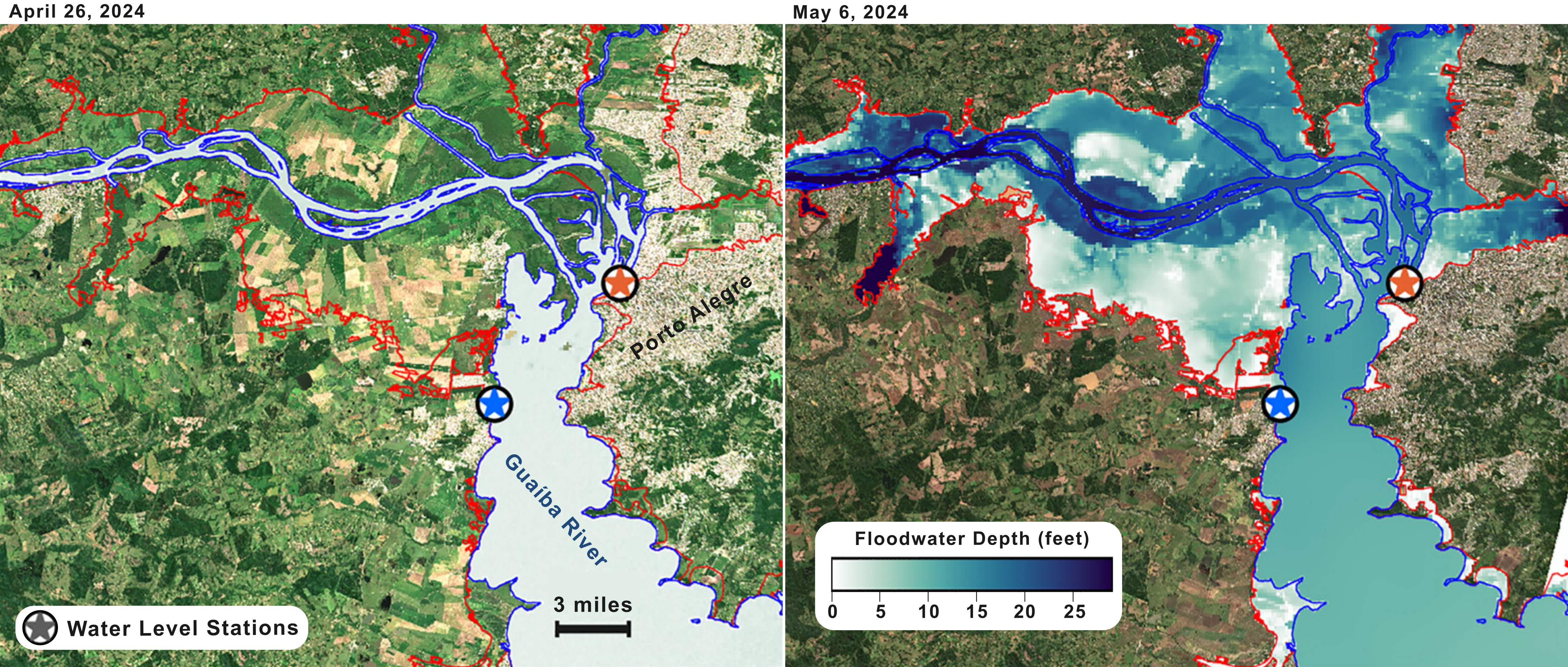
This figure overlays data from NASA’s SWOT satellite with topographical data. The left image shows the average water depth of the region, while the right image shows peak depth during the storms. Blue lines show permanent water channels from land-cover data. (Graphic credit ©Woods Hole Oceanographic Institution)
“What happened there is extremely upsetting,” said the study’s co-author, WHOI Physical Oceanographer Carolina Camargo, who is also from Brazil. “Understanding the cause of the flooding is just one part of the equation. It was also important for us to use these datasets to look at who was being impacted. We examined socioeconomic factors, such as income levels and healthcare outcomes, of the population within the study area and found that 16% of the 420,000 individuals displaced were considered socially vulnerable as defined by the Brazilian Institute for Applied Economic Research.”
The flooding also impacted approximately half of the region’s farmlands, creating challenges in the food supply chain locally and in areas beyond Rio Grande do Sul that rely on their exports.
“It’s nearly been a year and people are still trying to rebuild and searching for loved ones,” Simoes-Sousa continued. “We don’t know if catastrophic flooding will become more normal in the region, but these findings offer insights into floodwater distribution and can support mitigation strategies and disaster preparedness.”
This research was supported by Research Growth Donations to the Woods Hole Oceanographic Institution and by NASA under Grant 80NSSC21K0713.
###
About Woods Hole Oceanographic Institution
Woods Hole Oceanographic Institution (WHOI) is a private, non-profit organization on Cape Cod, Massachusetts, dedicated to marine research, engineering, and higher education. Established in 1930, its mission is to understand the ocean and its interactions with the Earth as a whole, and to communicate an understanding of the ocean’s role in the changing global environment. WHOI’s pioneering discoveries stem from an ideal combination of science and engineering—one that has made it one of the most trusted and technically advanced leaders in fundamental and applied ocean research and exploration anywhere. WHOI is known for its multidisciplinary approach, superior ship operations, and unparalleled deep-sea robotics capabilities. We play a leading role in ocean observation and operate the most extensive suite of ocean data-gathering platforms in the world. Top scientists, engineers, and students collaborate on more than 800 concurrent projects worldwide—both above and below the waves—pushing the boundaries of knowledge to inform people and policies for a healthier planet. Learn more at whoi.edu.