
Researchers Compile Most Detailed Map of an Underwater Eruption
November 1, 2007
Examining more than 50,000 seafloor images, geologists have created the most detailed map ever assembled for a volcanic eruption along a fast-spreading mid-ocean ridge. Researchers from the Woods Hole Oceanographic Institution, University of Florida, and University of Hawaii mapped where fresh new lava had paved over sediment-covered seafloor, while also identifying eruptive fissures and channels where lava had flowed. Scientists’ understanding of deep ocean volcanic eruptions has been limited by the ability to observe them. In April 2006, researchers got an unprecedented opportunity to investigate the dynamics of eruptions after discovering a recent lava flow along the East Pacific Rise (EPR) between 9° 46’ N and 9° 56’ N (900 km southwest of Acapulco, Mexico). Lead author Adam Soule and colleagues used support from the National Science Foundation’s RIDGE2000 program to conduct 37 surveys of the site with WHOI’s digital deep-sea towed camera system, plus another 10 dives in the submersible Alvin. In analyzing the imagery, they identified 186 sites where new lava met old. They documented that the eruption covered an area of 14.6 square kilometers with lava averaging 1.5 meters deep. More than 22 x 106 meters of lava were estimated to flow out of the Earth, yet it was only about 15 percent of what was stored in the magma chamber below the surface. The team observed that areas with the largest lava output coincided with the greatest concentrations of previously known hydrothermal vents. The map and findings were published online on November 26, with a printed version coming in the December issue of the journal Geology.
Related Links
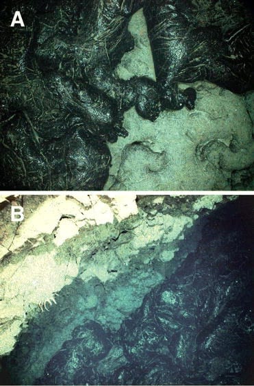
Images from the WHOI TowCam show where fresh lava covered up sediment-covered seafloor following a 2006 eruption along the East Pacific Rise. (Adam Soule, Dan Fornari, et al, Woods Hole Oceanographic Institution)