
2024 Potential Projects
Below is a list of potential projects and advisors in the WHOI departments and the USGS Coastal and Marine Science Center for Summer 2024. This list is not comprehensive; other Scientific and Senior Technical Staff are eligible to advise Summer Student Fellows. See also: WHOI Areas of Research and Departments, Centers and Labs. Projects for 2025 are posted here!
Applied Ocean Physics and Engineering Dept.
Ocean Acoustics and Signal Processing
Julien Bonnel Read more
AI and ML guided behaviors for underwater robots
Yogesh Girdhar Read more
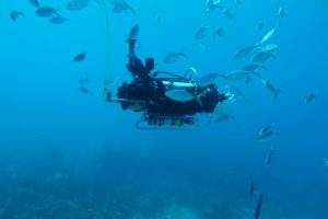 WARPLab does research related to developing novel AI and ML guided behaviors for underwater robots. Current ongoing projects in the lab relate to enabling robust operations of robots in coral-reef like environments that are geometrically and visually complex. We are developing capabilities to enable robots to automatically visually characterize habitat types, avoid obstacles, and follow marine animals. Students with a background in EE, CS, or MechE, and interest in robotics are encouraged to apply. WARPLab Oceanus article: A curious robot is poised to rapidly expand coral reef research
 Groundwater–ocean interactions from pole to pole
Julia Guimond Read more
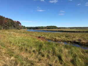
Salt marsh at Wells National Estuarine Research Reserve in Wells, ME.
Coastal areas are dynamic interfaces where the exchange between groundwater and seawater plays a crucial role in mediating coastal resources. These exchanges, influenced by forces like waves, tides, storms, and sea-level rise, can impact drinking water quality and the health of coastal vegetated ecosystems and estuaries. My research aims to better understand these complex interactions along diverse coastlines and assess their impact on coastal resilience. Through a combination of fieldwork, numerical modeling, and data analysis, my work spans the permafrost-bound shorelines of the Arctic to the saline marshes of the US East Coast and provides insight into the vulnerability and resilience of coastal ecosystems, communities, and economies globally. There are a range of potential summer projects within the realm of coastal groundwater studies. A few examples include:
- Arctic and New England Dynamics: Utilize existing datasets to examine groundwater flow and salinity patterns along Arctic beaches or New England salt marshes.

Guimond conducting geophysical surveys near Prudhoe Bay, Alaska.
- Modeling Groundwater Responses: Employ analytical or numerical models to simulate the effects of storm events and sea-level rise on groundwater systems.
- Geophysical Field Surveys: Collect and/or analyze geophysical data to map salinity distributions within coastal ecosystems.
These projects aim to advance our understanding of coastal groundwater processes and contribute to sustainable management strategies for coastal ecosystems and communities. Julia Guimond’s WHOI website Julia Guimond’s website
Applied Aquaculture
Scott Lindell Read more
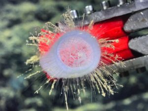
 The Applied Aquaculture Research Program (Lindell Lab) is researching and developing marine aquaculture for sustainably providing food, feed and fuel. We strive to develop methods that provide positive ecosystem services and economic development opportunities and minimal negative social and environmental impacts. This demands a multi-disciplinary approach encompassing various subsets of biology (e.g. genetics, physiology, ecology), and engineering. A major research focus is on selective breeding and improving hatchery/nursery processes for ocean farming sugar kelp (Saccharina latissima). We have two potential student projects for this summer: 1) screen and select heat-tolerant kelp varieties at different life stages that are resilient to changing ocean conditions. Our lab has hundreds of individual kelp strains collected from different environments that have yet to be tested. Students will gain experience with experimental design, microscopy skills, measuring algae physiology, and data synthesis. Results will be pertinent to selecting resilient kelp strains for farming or restoration projects.
 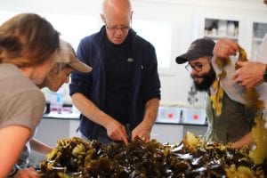 2) quantify several key metrics of kelp reproductive potential and success in a lab/nursery setting. This starts with spore production from selected farmed and wild kelp or from vegetative gametophytes in the lab, involves tracking the development and growth rate of kelp gametophytes, and optimal seeding density on string or rope substrates to be planted onto ocean farms. Students will gain laboratory skills pertinent to research and commercial seaweed nursery operations including microscopy, cell counting, and image analysis, as well as specialized skills such as preparation of kelp tissue for spore release and identifying different life stages of kelp. All projects will equip students with data collection and analysis skills, and experience working in a kelp nursery. Scott Lindell's profile
 Sea Ice Physics and Ice-Ocean-Climate Interactions
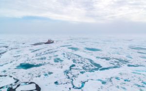
Ted Maksym Read more
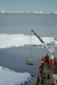
Deploying an autonomous underwater vehicle under the sea ice to map its thickness
The Maksym lab works on sea ice physics and ice-ocean-climate interactions at both poles. The lab's broad goals are to understand fundamental ice-ocean interactions that drive seasonal ice growth and decay to better understand drivers of sea ice variability and long-term change. The annual advance and retreat of Arctic and Antarctic sea ice is among the greatest seasonal events on earth. It is also one of Earth’s most rapidly changing environments. Our research focuses on fundamental sea ice physics and ice-ocean-climate interactions at both poles to better understand the drivers of sea ice variability and long-term change. This is accomplished through a combination of in situ observations (particularly using autonomous platforms and robotic vehicles), satellite data analysis, and modeling. Potential projects in my lab fall into three main areas. We have several projects that use data from ICESat-2, a satellite altimeter which can detect sea ice elevation with a precision of 2 cm. We are using these data for a range of projects including monitoring the evolution of snow depth on sea ice in the Antarctic, the connection between ice thickness and spring phytoplankton blooms in the coastal Arctic, and quantifying ice growth and melt in coastal Antarctica. For those with a preference for working with in situ observations, another project could include analysis of ice growth and melt data from drifting buoy platforms from the Arctic or Antarctic. Or, a prospective student could be involved in laboratory experiments to understand the mechanisms controlling the growth and development of snow-covered sea ice. Students should have some familiarity with programming environments such as Matlab or Python. An interest in working with satellite imagery, or experience with laboratory of field instrumentation would be an asset. The student can expect to learn how to analyze different types of satellite data and imagery, work with large climate date sets, and gain experience working with instrumentation and electronics. Ted Maksym's profile
Development of In situ Chemical Sensors
Anna Michel Read more
 Our interdisciplinary (engineering and chemistry) research focus is on advancing environmental observation through the development and deployment of novel sensors for measurement of key chemical species. In my lab, we design, build, and deploy advanced laser-based chemical sensors for environments ranging from the deep sea to Arctic environments. We are especially interested in bringing new technologies to the field for measurement of the greenhouse gases methane and carbon dioxide. An additional focus of our lab is on bringing adaptive sampling to ocean and earth science. More recently, we have been developing approaches for detecting microplastics in the ocean.
Projects can include developing and testing small gas sensors, investigating microplastics in ocean environments, advancing small platforms (including underwater remotely operated vehicles, surface vehicles, or drones) for making environmental measurements, and using machine learning approaches for data analysis. Our group includes members with interests in environmental chemistry, engineering, computer science, and physics, but we welcome anyone with interests related to our research. Students can expect an interdisciplinary research experience.
Upper ocean physics from the Arctic to Cape Cod
Maddie Smith Read more
 1. Waves are important drivers of coastal change around the world. On short time-scales, waves can drive large changes in bathymetry which impact wave evolution and local mixing. This project will use high-resolution measurements of waves over around 5 miles off the coast of Martha’s Vineyard from a novel method to quantify parameters of wave transformation.
 2. Arctic sea ice is a key part of the climate system particularly because of its brightness (albedo) which reflects much of the incoming solar energy. Changes in sea ice with a warming climate may feedback to further changes in the Arctic climate system. This project will use observations of sea ice brightness and light transmission from the MOSAiC expedition (link: https://mosaic-expedition.org) to quantify the impact of surface types and sea ice inclusions on the energy budget and sea ice melt.
This work will be mostly computer-based analysis of existing datasets, but there may be opportunities for contributing to local shore-based fieldwork, if desired. Students should have some background in physics or earth science, and an interest in coastal and/or polar regions. Some familiarity with coding in Python or Matlab would be beneficial, but improved coding and analysis skills can be expected as part of the fellowship regardless of the starting level. Students can expect to gain insight into physics of our rapidly changing Arctic and coastlines, and methods used to understand them. Maddie Smith's profile page
Autonomous Surface Vessel Development
Peter Traykovski Read more

WHOI Engineers and scientists have recently developed the Jetyak Autonomous Surface Vessel (ASV), which has enabled interesting measurements in environments ranging from the Arctic to Coastal Estuaries. See http://www.whoi.edu/oceanus/feature/the-jetyak. However for many applications a smaller ASV that could be launched and recovered by one person would be more suitable. In very rough conditions (e.g. the surf zone) the gas engine of the jetyak is problematic. Summer Student Fellow Projects that continue in the development of a smaller electric motor and battery powered ASV are possible that cover topics ranging from mechanical design to adaptive robotic control in the surfzone. Sensor integration such as bathymetric sonars or camera systems could also be part of a project These projects would involve significant amounts of hands on engineering and field testing. Peter Traykovski's profile Projects website
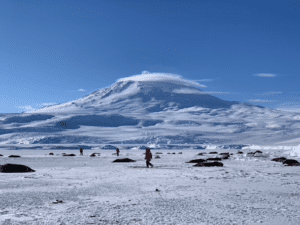
Antarctic ice-ocean interactions using satellite remote sensing
Catherine Walker Read more

Remote sensing satellites like ICESat-2 help to understand how the changing ocean interacts with towering ice shelves and glaciers around Antarctica.
Research on ice-ocean interactions is quite broad. The main focus of research, both on Earth (Antarctica! Greenland! Alaska!) and in space (Jupiter’s moon Europa! Saturn’s moon Enceladus!), will be to understand how ice-ocean systems change over time. Example projects in this topic could focus on either remote sensing or modeling. Using remote sensing techniques that involve laser altimetry and satellite imagery, we can focus on how ice is changing on Earth due to interactions with the ocean, particularly in how it will change with the climate. One sample project focus would be to focus on coastal glaciers in Antarctica and how they interact with changes in the surrounding ocean waters. We can also monitor iceberg breakup and sea ice changes and its effects on ice shelf stability. Understanding how coastal topography changes with shifts in ocean properties is also of interest. Another research focus is the development of instrumentation to observe these systems. Alternatively, modeling studies of ice fracture and subsurface water in planetary bodies (“Ocean Worlds”) are of interest as well, to determine how and when these bodies were active. Specifically, we can help to determine where the best place to land a spacecraft might be! A specific project might be using remote observations and modeling to determine how the soon-to-launch Ganymede Laser Altimeter will perform over bumpy ice surfaces. Desired skills include Matlab or Python or other coding experience, and interest in learning about ice dynamics, planetary science, and/or climate change. At this time, none of the projects require hands-on lab work, though that can be discussed as a possibility. Catherine Walker's profile NASA Highlight webpage
Ocean Currents and Biological Impacts
Weifeng (Gordon) Zhang Read more
My research focuses on ever-changing ocean currents in diff erent parts of the ocean and their impact on biology, such as phytoplankton distribution and fish behavior. As part of the Northeast U.S. Shelf Long-Term Ecological Research (NES-LTER) program, we have been analyzing observations on the continental shelf south of Woods Hole. The goal is to use observed physical environment to reveal causes of changes in the ecosystem. There are a range of possible summer projects related to this for motivated undergraduates. For instance, students could analyze observational data from Ocean Observing Initiative moorings and satellites to understand changes in temperatures and flows, and then use them to investigate causes of unexpected sudden phytoplankton blooms or daily vertical migration of fishes. There are also opportunities to participate in cruises and computer modeling. Weifeng (Gordon) Zhang profile Northeast U.S. Shelf Long-Term Ecological Research (NES-LTER)
Biology Dept.
Interactive effects of multiple stressors on early life stages of vertebrates; Developmental neurotoxicity of environmental contaminants
Neel Aluru Read more
- Interactive effects of multiple stressors on early life stages of vertebrates: The aim of this project is to understand the role of climate change stressors such as elevated carbon dioxide and hypoxia on early life stages of ecologically important fish species (e.g., Atlantic silverside). We have previously demonstrated that exposure of Atlantic silverside embryos to combined stressors (carbon dioxide and hypoxia) delayed development (time to hatch) and growth. We are currently investigating the biochemical and molecular changes underlying these phenotypes. Students will have the opportunity to participate in these studies. They will get hands on experience in conducting wet lab experiments as well as learn skills in biochemical, molecular and bioinformatic approaches.
- Developmental neurotoxicity of environmental contaminants: The overall objective of this project is to understand the effect of exposure environmental chemicals on developing nervous system. Using zebrafish as a model system, students will have an opportunity to conduct developmental exposure experiments, use confocal imaging for quantifying changes in the nervous system and conducting gene expression analysis.
Marine Predators
Camrin Braun Read more
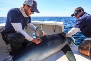
Capt. Willy Hatch and scientist Camrin Braun deploying electronic satellite tags on an adult blue shark offshore from Cape Cod. (T. Sinclair-Taylor)
In the Marine Predator Group, we use computational, lab and field-based approaches to study how predators interact with their environment and what that can tell us about how the ocean works. In our completely unbiased opinions, we have the best jobs in the world! We get to spend our time asking questions like: How does temperature affect when and where sharks migrate? How does the highly dynamic nature of ocean physics, with all its interacting currents, drive the formation of biological ocean “hotspots”? Why do many predators dive below the ocean’s surface to the seemingly inhospitable ocean twilight zone where its dark and cold? To answer these questions we leverage a highly interdisciplinary ocean ecology toolkit that includes, for example, using and developing electronic tags, analyzing remote sensing data from satellites, and exploring data from all kinds of in situ ocean sensors carried by ships, robots, moorings and even the predators themselves! Potential projects for Summer Student Fellows might include: [1] designing your own analysis of predator tag data from our existing database of nearly 2,000 tagged animals (e.g. explore deep diving behavior by tagged mako sharks, migratory cues of tagged albacore tuna, etc); [2] building species distribution models and investigating dynamic ocean management approaches for managing highly migratory predator species (e.g. how does a fishery closure protect important shark habitat); [3] conducting lab experiments to test new approaches for less invasive animal tagging methods (e.g. do state of the art suction cups provide the necessary strength and duration of attachment for tagging sharks, tunas and billfish species). It is helpful to have skills coding in R or Python, but these are not required and some fluency with one coding language will be gained over the course of the summer regardless. Fellows can expect to also gain experience in the field tagging predators and collecting any number of ocean measurements. Marine Predators Group website
Chemical defense in diatoms/Mixotrophy in marine food webs
Matt Johnson Read more
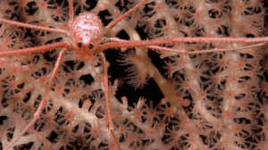
Connectivity of seafloor habitats in a changing Arctic
Kirstin Meyer-Kaiser Read more
Sensory biology and bioacoustics
Aran Mooney Read more
Diversity and Resilience of Seafloor Communities
Lauren Mullineaux Read more
 The Mullineaux Benthic Ecology Lab studies the dispersal of larvae of seafloor invertebrates through the ocean, their settlement back to the seafloor, and the influence of these processes on community resilience to disturbance - both natural and human. We use field observations, laboratory experiments, and mathematical models to understand how larvae respond to environmental cues and connect geographically separated communities. Our research helps solve problems in aquaculture and fisheries management, and informs policy on deep-sea mining. Students will have an opportunity to gain skills investigating larval behavior in turbulent flow (live animal experimentation and image analysis), recolonization of disturbed deep-sea vents (specimen identification and data analysis), or trophic interactions in a newly discovered deep-sea community on sulfide mounds (characterization of community composition; image and data analysis). Our lab group thrives on diversity and is committed to the highest standards of professionalism, including research integrity, collaboration, and respect for colleagues at all levels. Mullineaux Lab
 Mathematical Ecology
Michael Neubert Read more
Population phenology in nearshore ecosystems
Jesús Pineda Read more
Biological-physical interactions at mid-trophic levels
Mei Sato Read more
Marine Mammal Behavior and Communication
Laela Sayigh Read more
- Analysis of Galapagos sea lion vocalizations, to quantify patterns of occurrence and call parameters
- Analysis of acoustic recordings made in Wellfleet, MA as part of a project aimed at developing an acoustic mass stranding alert system for dolphins
- Analysis of a long-term database of recordings of bottlenose dolphins aimed at addressing a range of research questions about dolphin communication.
Deep-Sea Faunal Biodiversity, Genomics, and Resource Management
Tim Shank Read more
 The Shank lab is focused on understanding the ecological and evolutionary processes that structure deep-sea benthic biodiversity, including larval dispersal, colonization, habitat utilization, genetic connectivity, and the evolutionary relationships of invertebrate fauna. These studies include seamount and chemosynthetic ecosystems intimately tied to planetary processes significant to the evolution of life on earth. This research strives to provide fundamental insights into the rates and manner in which dynamic physical, biological, and geological processes structure biodiversity, and ecosystem response to disturbance and climate-related oceanographic/seafloor conditions. This coming summer, available projects include: 1) determining the biodiversity of benthic ecosystems, including hydrocarbon seep fauna, and critical minerals, from newly acquired imagery by a new class of Autonomous Underwater Vehicles (Orpheus class, co-developed by the lab) from new exploration of the US Aleutian trench and margin; 2) searching for novel genes and genomic composition of species in hydrothermal vent and trench ecosystems, 3) mapping the temporal changes in hydrothermal vent community succession using GIS techniques and deep vehicle imagery; and 4) determining seamount coral community structure from newly-discovered deep reefs in the Galápagos region. Students will learn fundamental skills- ecological approaches in the deep sea, fundamentals of DNA barcoding, and the implementation of comparative genomics. Students will also either participate on a research cruise utilizing deep remotely-operated vehicles, experience at sea discoveries (using the submarine Alvin) or interact with science teams via telepresence from sea. Contact: tshank@whoi.edu https://shanklab.whoi.edu/ https://www.whoi.edu/press-room/news-release/additional-galapagos-reefs/ https://www.whoi.edu/news-insights/content/the-rise-of-orpheus-2/
 Marine Mammal Physiology
Michelle Shero Read more
An Antarctic Weddell seal breeding colony at the base of the world’s southernmost active volcano, Mt. Erebus. (NMFS 23273)
In the Marine Mammal Physiology lab, we study adaptations that allow animals to ‘make a living’ in extreme and dynamic environments, and the selective pressures shaping life history strategies. In any population, why are some individuals so much more successful, that is, why do they survive and reproduce more than others? And how is success driven by physiological ‘decisions’ governing resource allocation? Projects would be lab based, and students would learn a variety of assays. Potential projects might include: 1) Assessing tradeoffs in female-to-pup iron transfer during lactation in grey seals from Sable Island, Nova Scotia. Iron is critical for seals to produce blood hemoglobin and muscle myoglobin that acts as an ‘internal scuba tank’ for long underwater dives, so there should be a balance between how much a female provides to the pup and how much she maintains for herself. 2) Energetics of Weddell seals from McMurdo Sound, Antarctica. We aim to determine whether pups born to the population’s most successful females (when it comes to producing pups) are weaned with greater lipid and iron stores. Both projects would provide opportunities for studies to learn techniques in isotope dilution, endocrinology, and trace metal analysis and mass spectrometry. Previous lab experience is a plus, but not required. Studying linkages between energy balance, performance capacities and behaviors, and reproductive success all build towards a central goal of understanding how marine mammals navigate ‘tipping points’ in their life history cycles – and identifying when animals are pushing their physiological limits such that they will have less plasticity to respond to a changing world. Shero Lab page
Phytoplankton Ecology
Heidi Sosik Read more
 My research is focused on quantitative plankton ecology and in my lab there are a range of possible summer projects for motivated undergraduates. Most on-going projects are related to coastal ecosystems and time series observations of plankton at scales from single cells up to large areas that can be monitored with satellite remote sensing. We have on-going field work as part of the Northeast U.S. Shelf Long-Term Ecological Research (NES-LTER) program and at the Martha's Vineyard Coastal Observatory, which is a facility on the continental shelf near WHOI that is connected to shore by power and fiber optic cables. We have developed some exciting new submersible flow cytometer technologies that rapidly measure microscopic particles (mostly phytoplankton, but also protozoa), including video imaging at the micron scale. These instruments are deployed at MVCO and produce lots of data (e.g., >10000 images per hour for months to years), so projects involving these time series can span from computer science (image analysis, computer vision, and machine learning) to modeling of populations and bloom dynamics. There are also opportunities for projects involving coastal field work, laboratory experiments with plankton cultures, and instrument development. Heidi Sosik's website Imaging Flow Cytobot data Northeast U.S. Shelf Long Term Ecological Research (NES-LTER)
 Marine Molecular Ecology
Carolyn Tepolt Read more
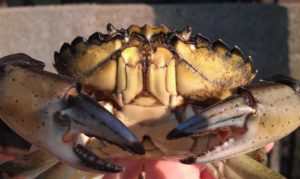
European green crab, named one of the IUCN’s “World’s 100 Worst Invasive Species”.
Our lab studies how – and how quickly – marine animals can adapt to new environments. We mostly study invasive species, which are extremely good at surviving and thriving in new waters. We use a range of approaches, including genomics, ecophysiology, ecology, and parasitology, and are interested in student fellows who want to develop their skills in those areas. Current research projects include adaptation to temperature in the highly invasive European green crab (pictured here) as it rapidly spreads on the west coast, adaptation to an invasive body-snatching parasite by a native mud crab, and the distribution and adaptations of marine microparasites using public genetic data. Our lab culture emphasizes professionalism, collegiality, and baked goods. Tepolt Lab
Geology and Geophysics Dept.
Simulating Icebergs in the Laboratory
Alan Condron, Claudia Cenedese, Olivier Marchal and Jack Whitehead Read more
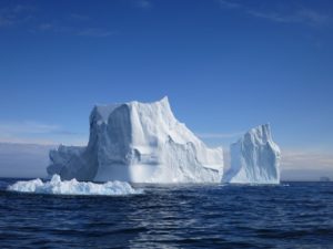 Much of the floor of the northern North Atlantic Ocean is covered by thick deposits of ice-rafted debris (IRD) that stretch all the way from Canada to the coast of Portugal, ~3,000 km to the east. These sediments were deposited throughout the last glacial period during Heinrich events, when icebergs were released from the major ice sheets fringing the North Atlantic Ocean. The alignment of these periods of ice-rafting with dramatic and large-scale changes in ocean and atmospheric circulation has often prompted the suggestion that the input of freshwater from melting icebergs played a critical role in altering glacial climate. Precisely how much ice and freshwater were involved in the formation of these ice-rafted sediment deposits is, however, largely unknown due to a very limited understanding of how much sediment is transported by icebergs. As such, the overall sensitivity of large-scale ocean circulation to freshwater forcing remains difficult to quantify. The goal of this exciting Summer Student Fellowship project is to simulate the transport of sediment by icebergs in the laboratory. The experiments will involve placing small ‘synthetic’ sediment-laden icebergs (made in a freezer) in a tank filled with saltwater to investigate how and where sediment ‘builds up’ on the tank floor. A creative set of experiments using icebergs with, for example, different sediment-loading patterns and drift speeds will be performed. The results from these experiments will then be used to improve simulations of Heinrich events made using the iceberg component of a numerical circulation model developed at MIT (MITberg). The ideal student should have some prior knowledge of fluid dynamics, physical oceanography, numerical modeling, and/or, paleoclimatology, although the most important quality is that the student is motivated! This exciting cross-departmental project will be co-supervised by WHOI scientists Alan Condron, Claudia Cenedese, Olivier Marchal, and Jack Whitehead. Alan Condron's profile Claudia Cenedese's profile Olivier Marchal's profile Jack Whitehead's profile
 Geochemical Paleoceanography
Kassandra Costa Read more
- Quantifying calcium carbonate burial in different sediment phases over time
- Reconstructing organic carbon production in the surface ocean and burial on the sea floor
- Investigating how carbon storage affects oxygen concentrations in the deep ocean
- Examining the foraminiferal assemblage response to changing climate conditions over glacial-interglacial cycles.
The SSF will join ongoing collaborations within our lab, and they will have the opportunity to learn multiple analytical techniques in geochemistry (230Th-normalization, major and trace elemental sediment geochemistry, metal to calcium ratios in foraminifera (ICP-MS) and micropaleontology (foraminiferal assemblages, d18O, d13C). These projects are lab based, and so students should be prepared to leave their computers behind to work with mud, acids, microscopes, and more. All techniques are accessible to students without prior experience but with the motivation to learn. Kassandra Costa's website
The transition from fracture to flow in marble
Andrew Cross Read more
- training and using an unsupervised machine learning algorithm to identify and measure cracks in SEM images
- using a Matlab program to measure crystallographic twins from electron backscatter diffraction (EBSD) maps
- receive hands-on training in the acquisition of SEM images and EBSD data at WHOI/MBL
- participate in virtual meetings with project collaborators at WHOI, MIT, and GFZ Potsdam
- travel to MIT to meet with collaborators and participate in a deformation experiment on Carrara marble
- interact with graduate students and postdoctoral investigators in WHOI’s Rock and Ice Deformation Laboratory
Interested students are encouraged to contact Dr. Andrew Cross (https://www.whoi.edu/profile/across/) to learn more about the project.
Projecting Coral and Reef Calcification in a Changing Ocean
Weifu Guo Read more
Distributed Acoustic Sensing (DAS), with a variety of seismic applications on the beach
Nicholas Harmon, Catherine Rychert, Wenbo Wu and Maddie Smith Read more
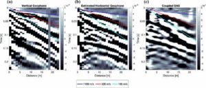
Example of surface deployed DAS recording of a seismic shot vs. a multichannel geophone recording (Harmon et al., 2022).
Distributed Acoustic Sensing (DAS) uses backscattered light from lasers transmitted through fiber optic cable to measure ground motions along the fiber, essentially turning the cable into hundreds to thousands of seismic sensors. This allows for the measurement of seismic and other environmental signals such as ocean waves and whale song at high spatial (cm-scale) and temporal scales (kHz). This technique is exploding because of its wide applications and versatility. Fiber optic cable is relatively inexpensive and easy to deploy in the field, opening up a wide range of environmental applications such as seismic and volcanic hazard monitoring to biological and oceanographic observation. In other words, surface deployed DAS is a new technique and there is an enormous opportunity to develop optimal field methods and advance or scientific understanding in a wide range of fields. The summer fellow will participate in a series of field deployments of DAS in field sites on Cape Cod including onshore offshore environments (beaches) to examine the feasibility of this type of surface deployment. The DAS will be deployed for passive and active seismic experiments to examine sensitivity of the DAS to a wide range of anthropogenic and environmental signals. The student will process the active seismic data and perform analysis on the continuous recordings to examine known signals such as ocean waves and nearby car and small boat noise. In addition, legacy datasets from land and submarine cables will be available for the student to explore, compare and interrogate. The ideal student will have a background in geophysics, geology, oceanography, physics, or mathematics. The student should have a basic knowledge of MATLAB or python and a willingness to deepen their skillset with computer programming. The student will develop skills in seismic network array processing and signal processing. The student will also develop skills in near surface geophysics survey design and execution, as well as oral and written presentation skills by presenting their work at group meetings. The student will work in a wider group at WHOI with Dr. Catherine Rychert, Dr. Madison Smith, Dr. Wenbo Wu, and PhD students and postdocs across the Geology and Geophysics and Applied Ocean Physics and Engineering departments. Nicholas Harmon Catherine Rychert Maddie Smith Wenbo Wu
Crustal structure beneath Puerto Rico from Marine Active Seismics
Nicholas Harmon, Pablo Canales, Catherine Rychert, Uri Ten Brink (USGS), et al. Read more
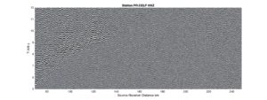
Shot gather of the vertical component with reduced time at station CELP from the Puerto Rican Seismic Network.
Puerto Rico is part of the relict Greater Antilles Arc that was constructed in the Cretaceous as the Caribbean Plate converged on the North and South American plates. The island has also been subjected to large tectonic motions, which has further shaped the region. Subduction is still occurring to the north of the island at the Puerto Rico trench at a very oblique angle, as well significant seismicity associated with the Muertos Trough to the south, making Puerto Rico a region of high seismic hazard. The crustal structure of Puerto Rico is important for our understanding of the evolution of the Greater Antilles Arc and the development of the Caribbean as well as understanding the seismic hazard of the region. In late fall 2023, the “Collaborative Research: Seismic Hazard, Lithosphere Hydration, and Double-Verging Structure of the Puerto Rico Subduction Zone: A Seismic Reflection and Refraction Perspective” project collected multichannel seismic and refraction data using airgun shots from the RV Marcus G Langseth to study the structure of the Puerto Rico Trench and Puerto Rico for a better understanding of hazard on the region. Several thousand shots were recorded on the permanent seismic network on land. The three component seismic data provides an opportunity to examine P-to-S wave conversions beneath the station generated at seismic velocity discontinuities below the station. The student will use the receiver function method to examine seismic velocity discontinuity structure beneath the seismic network and understand the construction the crust of Puerto Rico. The receiver function data will then be migrated to depth to construct a 2-D image of the structure beneath the station, which can be used to understand the layering with the crust and its construction. This is an amazing opportunity to provide tight constraints on Earth structure which are imperative to earthquake hazard mitigation in the region, with broader implications for our understanding of regional tectonics and the tectonic plate. The ideal student will have a background in geophysics, geology, oceanography, physics, or mathematics. The student should have a basic knowledge of MATLAB or python and a willingness to deepen their skillset with computer programming. The student will develop skills in seismic network array processing and signal processing. The student will also develop skills in active source seismics, as well as oral and written presentation skills by presenting their work at group meetings. The student will work in a wider group of scientists at WHOI and at the University of Puerto Rico, University of Texas and the US Geological Survey with Dr. Pablo Canales, Dr. Elizabeth Vanacore (UPR), Dr. Uri Ten Brink (USGS), Dr. ShuoShuo Han (UT), Dr. Catherine Rychert and PhD students and postdocs across the Geology and Geophysics Department at WHOI. Nicholas Harmon Pablo Canales Catherine Rychert Uri Ten Brink (USGS Woods Hole)
Entrainment of glacial meltwater by the North Atlantic Current: A numerical study
Olivier Marchal and Alan Condron Read more
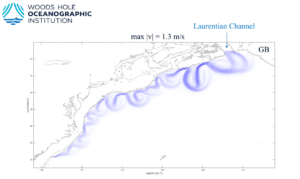
High-resolution numerical simulation of the coastal current produced by the discharge of glacial meltwater from the Laurentian Channel during a glacial period of low sea level. Shown is the distribution of surface horizontal velocity after 150 days of sustained discharge. The maximum speed of the current is 1.3 m/s. The current has developed eddies all along the continental slope. This project will be concerned with the analysis of a similar simulation but for a larger domain including the oceanic region east of the Grand Banks of Newfoundland (GB) (O. Marchal and A. Condron, unpublished)
Paleoclimate records suggest that the last glacial period was punctuated by a series of rapid climatic changes. Although these changes were first documented in the circum North Atlantic, subsequent studies indicated that they may have been at least hemispheric in extent. The estimated magnitude of these changes is truly impressive. For example, ice core records from Central Greenland suggest that local air temperature increased repeatedly by 8-16oC in only about a century. With such a discovery, the once-traditional view that climatic changes are slow, with time scales far exceeding a human lifespan, has been overthrown, and understanding the processes leading to these changes has emerged as a most pressing question in climate research. A popular idea to explain rapid past climate changes involves the recurrent release of glacial melt water from the Laurentide Ice Sheet (LIS) – the ice cap that covered northern North America during the last glaciation. The introduction of glacial water into the ocean would have lowered the salinity of surface waters, particularly at high latitudes in the North Atlantic, thereby leading to enhanced vertical density stratification, reduced deep water formation, and ultimately, abated meridional overturning circulation and northward heat transport. The abated northward heat transport would have produced a rapid climate change, with cooling in parts of the northern hemisphere, such as in the northern North Atlantic. The goal of this project is to analyze detailed simulations of the transport of glacial meltwater in the North Atlantic which will be produced from a high-resolution numerical model of ocean circulation. In contrast to previous studies, our simulations will represent oceanic eddies with scales of 10-100 km, thereby allowing a detailed calculation of the pathway of the glacial water in the North Atlantic. Emphasis will be put on the entrainment of glacial water emanating from the LIS with the North Atlantic Current – the northeastern extension of the Gulf Stream east of the Grand Banks of Newfoundland – and on the transport of the glacial water to critical regions of deepwater formation. The student working on this project will be exposed to concepts emanating from various disciplines, including physical oceanography, the numerical modeling of ocean circulation, and paleoclimatology. Although prior exposure to branches such as physics and calculus would be desirable, the most important quality the student working on this project should have is motivation! This project will be co-supervised by WHOI scientists Olivier Marchal and Alan Condron. Olivier Marchal's profile Alan Condron's profile
The history of O2 in ancient oceans
Sune Nielsen Read more
The Nature of the Hawaiian Plume from Scattered Seismic Waves
Catherine Rychert and Nicholas Harmon Read more
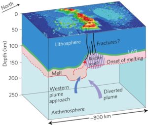
Schematic of Hawaiian Plume Lithosphere interaction (Rychert et al., 2013).
Hawaii is the classic example of a mantle plume, where hot focused upwelling in the mantle leads to a volcanic island chain. Yet the origin and the processes that give rise to the Hawaiian volcanos are still the subject of vigorous debate. For example, where does the plume originate from, how wide is the plume is and how hot is it? One of the primary ways for investigating the nature of the Hawaiian plume come from seismic observations of the lithosphere-asthenosphere boundary (the boundary at base of the tectonic plate) and the mantle transition zone at 410 and 660 km depth. Interactions of the plume with the plate and also the mantle transition zone, the gate keeper of the mantle which plays a primary role in dictating mantle convection, are fundamental to our understanding of mantle dynamics and Earth’s evolution. Yet, the characteristics of the plume are debated, in part because most constraints come from a single methodology or dataset. Here we will develop an interdisciplinary and wholistic view of Hawaii and its plume. The student will use existing ocean bottom and land seismic data to examine the lithosphere-asthenosphere and mantle transition zone boundaries. The student will use existing SS wave precursor stacks, S-to-P and P-to-S receiver functions to develop a unified velocity discontinuity model for Hawaii. The student will use synthetic seismogram modelling to determine the optimal models and data combinations that produce a unified Earth structure. This will yield a high resolution image of the mantle structure beneath Hawaii and constrain the location, width, structure and temperature of the Hawaiian plume. The ideal student will have a background in geophysics, geology, oceanography, physics, or mathematics. The student should have a basic knowledge of MATLAB or python and a willingness to deepen their skillset with computer programming. The student will develop skills in seismic network array processing and signal processing. The student will also develop skills in passive source seismology specifically the receiver function method and SS precursor imaging, as well as oral and written presentation skills by presenting their work at group meetings. The student will work in a wider group of scientists at WHOI and Scripps Institution of Oceanography with Dr. Nicholas Harmon, Prof. Peter Shearer (SIO) and PhD students and postdocs across the Geology and Geophysics Department at WHOI. Nicholas Harmon Catherine Rychert
Marine ecosystems in deep time
Elizabeth Sibert Read more
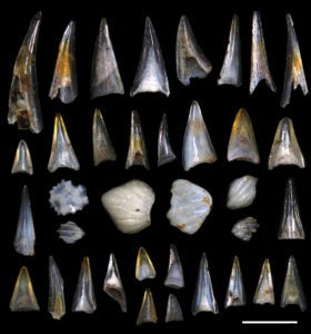
Microfossil fish teeth and denticles, approximately 50 million years in age, from DSDP Site 596, a marine sediment core from the South Pacific ocean. The scale bar is 500 microns, and the fossils were imaged using a high resolution digital microscope.
Understanding how life has responded to past global change events is vital to predicting and mitigating anthropogenic impacts on the planet. The Paleo-Biological Oceanography lab explores how marine ecosystems have responded to environmental changes in earth’s history, going back hundreds of millions of years. This work lies at the intersection of biological oceanography, ichthyology, paleobiology, and paleoceanography, and is driven by big-picture questions, including: How have marine ecosystems evolved throughout Earth’s history? How did past climate and biotic events impact the structure, function, and evolution of marine ecosystems, and what can that tell us about potential impacts of future global change? How has the evolution of pelagic marine vertebrates, particularly fish and sharks, interacted with changes in the Earth system? To investigate these questions, we leverage an interdisciplinary toolkit that centers around microfossil fish teeth and shark scales (ichthyoliths) preserved in marine sediments in conjunction with fish biology, paleo-proxies, ecological models, and evolutionary tools, to study how fish, sharks, and marine ecosystems have evolved in concert with climatic and biotic changes throughout Earth’s history. Interested students are welcome to propose a particular time or event in Earth’s past to investigate, or can pick up a project that is currently ongoing. Ongoing projects include looking at fish and shark biodiversity and abundance across the Cretaceous-Paleogene Mass Extinction and to several major global warming and cooling events in earth’s past, developing a catalog of modern shark scale and fish tooth morphological diversity, machine learning applications to identifying and cataloging microfossils. No prior microscopy, fossil prep, sediment processing, or computer coding experience necessary, but a willingness to learn and develop these skills is essential. A student project would likely be primarily lab based with some computer programming and image processing, though the exact scope is determined by the student’s research interests. The work generally includes sediment processing (sieving and chemical separation), picking for fossils using a dissection microscope, high resolution digital imaging, dissection of collections-based fish and shark specimens, morphological characterization, and data analysis and interpretation using R. Students will work in a fully wheelchair-accessible lab space, and join a team of researchers dedicated to diversity, inclusion, and accessibility in STEM. Elizabeth Sibert website: https://elizabethsibert.com/ Accessible Sharks Webpage: https://accessiblesharks.wordpress.com/
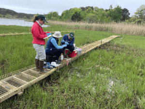
Groundwater fluxes using the "heat as a tracer" method
Robert Sohn Read more
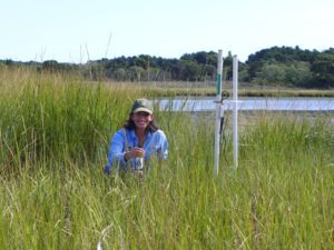
National Park Service scientist Petra Zuniga deploys a temperature profiler at the Herring River restoration site in Wellfleet, MA.
Understanding the interaction between surface water and groundwater is a fundamental aspect of ecosystem and biogeochemical cycling studies in aquatic environments. Surface water penetrating into sediments (infiltration), groundwater discharging into the water column (discharge), and surface water that flows through shallow sediments before returning to the water column (hydrodynamic exchange), all play an important role in modulating solute and nutrient fluxes, but these fluxes are very difficult to measure, and they often exhibit considerable spatial and temporal variability. The simplest way to constrain fluxes is by measuring the sediment thermal gradient because fluid flux modulates both the steady state gradient and the downward diffusion of surface water temperature changes into the sediment. Heat is thus a tracer that can be used to constrain flux rates, and in contrast to other methods, temperature sensors are robust, inexpensive, and essentially maintenance-free. This project involves using newly developed, state-of-the-art, thermal instrumentation to measure groundwater fluxes in natural environments around Cape Cod, and to conduct controlled experiments in a newly built test tank in the AVAST facility. The ideal student will have a background in physics and some experience using Matlab software, though neither is strictly speaking necessary if there is a willingness to learn. Rob Sohn's profile
Marine Chemistry and Geochemistry Dept.
Understanding Marine Snow Particles
Ken Buessler Read more
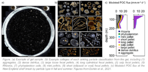 In Café Thorium’s lab we have been estimating carbon fluxes in the ocean since the late 80’s. Thorium is just one of many radioactive elements we measure. We analyze samples for both natural and manmade radionuclides. By knowing their source term, geochemistry, and radioactive decay properties, we use radionuclides as in situ tracers of a wide variety of chemical, biological and physical processes. Our techniques also include sediment traps, underwater cameras (UVP type), and particle incubations. Physical and biological processes occurring in the surface ocean generate a vast diversity of particles. These particles represent potential vehicles to export organic carbon to the deep ocean, where a small fraction can eventually be sequestered in the sediments. This process, known as the “biological pump”, influences the level of atmospheric carbon dioxide and thus the global climate system. Because of the complexity of this mechanism and its spatial and temporal variability, our predictions of the efficiency of the biological pump in varying conditions remain poorly constrained. A better understanding of particle properties is needed to reduce uncertainties. “Gel traps” allow for the collection of intact natural particles as they sink in the water column, and thus give a direct “picture” of the sinking flux at the depth of trap deployment. Image analysis of particles embedded in gels can provide particle statistics, and conversion from area to volume and from volume to carbon content, using empirical relationships, allows for estimation of the carbon flux and the relative importance of each category of particle. In this summer project a total of 15 gel samples from 2 different cruises in the North Atlantic will be visually examined by microscopy to quantify the flux and identity of individually sinking organisms. Cruises were carried out as part of WHOI's Ocean Twilight Zone (OTZ) project. Sinking particles and organisms that settle into the gel layer remained distinctly separated, preserving original characteristics of size and quantity and constituents. The images well serve us to 1) group marine snow in different visual categories, 2) estimate particle sinking fluxes in the ocean, 3) assess oceanic carbon export by particle type by using allometric relationships, 4) link particle visual properties to particle carbon content and particle sinking rates, and 5) compare images from gel samples with existing images from particle collected with Niskin bottles as a proof of concept. If you have basic knowledge of microscopy and marine taxonomy and an interest in learning about particle imaging techniques and their use to study the ocean, we encourage you to check out our group. You will be responsible of 1) taking images of gel sediment trap samples under the microscope for several magnifications, 2) running the existing python-based image processing scripts to analyze gel trap images by recognizing particles in an image, and then counting and measuring them, 3) estimating particle sinking fluxes from gel samples images, 4) comparing estimated fluxes to fluxes measurements available from other techniques used in the lab (e.g., sediment trap, Thorium-234 an, and UVP images), and 5) elaborating a synthesis report of activities carried out and main results. As a summer student in Café Thorium, you will learn about the many techniques we use to estimate carbon fluxes in the ocean and experience the dynamic environment that life at WHOI offers. Café Thorium website: https://cafethorium.whoi.edu/ OTZ project: https://twilightzone.whoi.edu/ Ken Buessler profile
 Ecological and applied roles of bioactive secondary metabolites in marine sponge symbioses
Colleen Hansel Read more
The glass sponge Venus’ flower basket (Euplectella spp.) sampled with ROV SuBastian near Puerto Rico in spring 2023.
The Hansel Lab investigates the interactions between marine organisms and their geochemical environment by integrating geological, chemical, and biological perspectives. In doing so, our research encompasses several domains of life spanning bacteria to corals, explores elements both essential (e.g., oxygen) and detrimental (e.g., chromium) to life, and spans diverse geochemical niches (from coral reefs and the deep-sea on Earth to rock varnish on Mars). This summer, a summer student fellow will have the opportunity to investigate the microbial symbionts of mesophotic and deep-sea sponges (often made of glass!). Microbe-sponge symbioses are known to produce molecules with applications in medicine, agriculture, and biotechnology, and mesophotic and deep sea sponges are vastly understudied. Under the guidance of PhD student Kate Lane, the student will lead their own project using mesophotic and deep-sea fungi isolated by Lane on a recent cruise to Puerto Rico. This project will include characterizing the fungi (using genetic sequencing and computational methods) and experiments aimed to discover novel bioactive secondary metabolites (microbiology and biochemical methods). The student will also have the opportunity to participate in fieldwork at a local coastal pond impacted by sea level rise, thus gaining hands-on experience in both laboratory and field methods in marine science and biogeochemistry. No specific skillsets are required and we encourage students from all backgrounds with interest in our lab’s research to apply. Our lab group is committed to diversity, collaboration, integrity, and respect. Hansel Lab
Ocean circulation and climate
Sophie Hines Read more
Isotope Biogeochemistry
Tristan Horner Read more
Ben Geyman (2016 SSF), Tristan Horner, and Maureen Auro inspecting a trace-metal sample in the clean room. (Tom Kleindinst, WHOI)
Micronutrients are important, low-abundance elements that profoundly shape marine processes. Barium, cadmium, iodine, and iron, among others, play multifaceted roles—from actively driving biogeochemical transformations to acting as passive tracers of ocean circulation. My research is fascinated by these processes, and I focus on three major questions: What is the distribution of micronutrients in the marine environment? How are these distributions sustained? And how do marine sediments serve as archives of these distributions? Opportunities for summer 2024 include: investigating the distribution of key micronutrient elements in the ocean through measurements or modeling; quantifying the rates and dependencies of micronutrient cycling processes via laboratory-analogue experiments; and, examining marine sediments to reconstruct the Earth’s biogeochemical evolution. I seek driven, inquisitive students who are eager to learn and apply new techniques in studying marine biogeochemistry. Summer Student Fellows in the NIRVANA Lab can anticipate hands-on training in processing samples for multi-element and isotope analysis within our state-of-the-art clean room (pictured). Alternatively, you could learn how to leverage machine learning to predict micronutrient distributions in ocean. No prior experience is necessary; you'll acquire relevant skills through close collaboration with current lab members. Additionally, I encourage SSFs to develop their projects into Senior Theses and to showcase their work at regional and national scientific symposia. Past projects have also led to peer-reviewed publications (e.g., Geyman et al., 2019; Dunlea, Tegler, et al., 2021; Mete et al., 2023). If our research sounds interesting, I invite you to apply for an SSF in the NIRVANA Lab in summer 2024. Tristan Horner's profile NIRVANA research group
Marine Chemistry, Instrumentation and Engineering
Matthew Long Read more
 My research explores the ways that natural and anthropogenic processes influence the structure and function of marine ecosystems through unique engineering solutions, advanced instrumentation, and technology development. Studies of biogeochemical cycling, physical transport processes, and bio-physical interactions are principle components of my research into carbon and nutrient cycling in coastal environments. These topics are significant because the long-term effects of human activities, which are rapidly altering climatic conditions and nutrient cycling, are not well understood. Opportunities in my lab include the development of low-cost sensors through electro-mechanical engineering, development of advanced sensors and control systems, and field application and testing of sensing platforms. Advanced sensing systems collect high-frequency data (e.g. water chemistry, turbulence) which is
 Ocean Observing and Modeling to Understand Biogeochemical Cycles and Carbon Fluxes
David (Roo) Nicholson Read more
In-situ dissolved gas tracers of physical and biogeochemical processes
Alan Seltzer Read more
CO2 Chemistry, Ocean Acidification and Sensor Development
Zhaohui Aleck Wang Read more
 (1) Climate solution: Marine CO2 Removal (mCDR). The consensus of the climate science community is that reduction of carbon emissions alone is not enough to curb the global mean temperature increase below 2°C at the end of this century, the threshold that catastrophic consequences of global warming may occur. Global society needs to take action to remove CO2 from the atmosphere to subsidize the effort of carbon emission reduction to achieve the goal of <2°C warming. We have started a few projects to study marine CO2 removal methods and their potential environmental impacts. Naturally, tidal wetlands, such as salt marshes and mangroves, remove large amounts of CO2 from the atmosphere. We leverage these ‘blue carbon’ ecosystems to develop a novel, advantageous approach to coastal mCDR, which couple CO2 capture by coastal wetlands with enhanced coastal Ocean Alkalinity Enhancement (OAE) and local-scale Ocean Acidification mitigation. In OAE, basic minerals or solutions are added to seawater to increase its alkalinity and thus the capacity of CO2 uptake. The student will have the opportunity to participate in the multi-institution project to conduct lab and field experiments to test the new method and assess its benefits and impacts, particularly related to carbonate chemistry and CO2 fluxes. (Photo 1. Sampling porewater chemistry in mCDR treated marsh sediments.)
 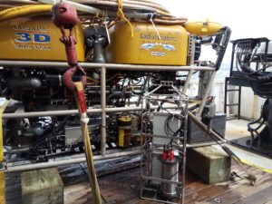 (2) New-generation in situ carbon and pH sensors. The goal of this work is to develop low-cost in situ sensor system for high-frequency measurements of seawater CO2 parameters, i.e., pH, pCO2, dissolved inorganic carbon (DIC), and alkalinity (Alk). We will leverage this development and our on-going collaborations with the fishing community, NOAA fishery, and citizen scientists for large-scale deployments of these sensors to establish a cost-effective, wireless connected, openly accessible coastal carbon observing network. The student can join the sensor development team to learn engineering skills (electronics, optics, mechanics, and software) as well as seawater carbonate chemistry to develop various in situ sensors to seawater CO2 parameters. (Photo 2. Deployment of a Channelized Optical System (CHANOS) II DIC sensor on ROV Global Explorer) Zhaohui 'Aleck' Wang's profile
 Sunlight-driven degradation of organic carbon in the surface ocean
Collin Ward Read more
Marine Policy Center
Studies of Coupled Nature-Human Systems
Yaqin Liu, Michael Weir, Di Jin and Hauke Kite-Powell Read more
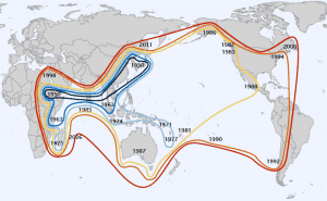
This figure depicts the economic geography of global sea cucumber exploitation from work undertaken by 2017 SSF Kate Rawson from Mount Holyoke College. Temporal isoclines show fisheries expanding as those more proximate to the main Asian market become overexploited and fail to meet demand. Colored lines represent the global distribution of sea cucumber fisheries within a given decade; specific starting years of some fisheries are labeled over the general location of the largest city (by population) within the participating country.
Marine Policy Center Researchers at the WHOI Marine Policy Center (MPC) conduct social scientific research that integrates economics, policy analysis, and law with WHOI’s basic research in ocean sciences. While MPC’s research is based in rigorous academic disciplines, such as economics, much of it is applied in nature and motivated by current issues in coastal and marine resource management. Areas of recent research include: human responses to shoreline change; the economic effects of harmful algal blooms; the consequences of channel deepening in major estuaries; ecosystem-based fisheries management; aquaculture development and fisheries management in developing countries; and coastal and marine spatial planning. Students are offered the opportunity to choose project topics from a list of current projects or to develop their own projects. Many MPC student projects involve exploring the impacts of human activities on the coastal or marine environments by linking economic models to models of natural systems. Yaqin Liu Economics of Recovering Rare Earth Elements Rare earth elements (REE) consist of 17 elements that are essential in several clean energy technologies that are crucial in the race towards net zero carbon emissions. For example, offshore wind turbines and electric vehicle motors use neodymium, praseodymium, dysprosium, and terbium in their permanent magnets (Baron, 2020). Global REE mine production is concentrated in a few countries, with about 70% coming from China. While substantial U.S. federal government funding has been awarded to determine the technical feasibility of recovering REE from coal and coal byproducts, there remains significant uncertainties associated with the economic feasibility and the environmental impact of such processes. The proposed project aims to provide independent assessment of the economic efficiency of recovering REE from coal and coal byproducts and its environmental impact in the United States. The student will learn and practice downloading, merging, cleaning data (R or Stata), conducting statistical analysis to answer important societal questions. Any inquiries – please shoot me an email - https://directory.whoi.edu/profile/yaqliu/ Michael Weir Measuring Ocean Literacy and Willingness to Pay for Ocean Twilight Zone Conservation Species that live in the ocean twilight zone, or OTZ, play a fundamental role in global climate by transporting significant amounts of carbon from the upper ocean into the deep sea. In addition, species populations in the OTZ are estimated to be larger than total catches of all other fisheries in the world today. There is a growing interest in harvesting fish from the OTZ, but little is known about public perceptions of OTZ conservation which is essential for developing effective fishery management policies. For this project, we will use economic survey methods to measure the public’s ocean literacy and willingness to pay for OTZ biodiversity conservation. You will learn about the methods economists use to value natural resources, how to develop an effective survey, and analyze survey data to investigate the monetary value of OTZ conservation. Learn more about my other projects here! Di Jin Marine Resource Management under Changing Social and Ecological Conditions Sustainable marine resource management must adapt to short- and long-term changes in social and ecological conditions. The project will explore long-term trends in fisheries and aquaculture production and trade, as well as relevant changes in resource conditions and management policies. The analysis will use historical data from NOAA Fisheries and FAO and ecosystem parameters from the marine scientific literature. Selection of a specific study area, species, and policy issue will be jointly determined with the student. Examples of research topics include, but is not limited to, US seafood production under climate change, marine spatial planning for multiple ocean uses (fishing and offshore wind), potential harvest of marine resources from the ocean twilight zone, and impacts of Harmful algal blooms (HABs).
Physical Oceanography Dept.
Simulating Icebergs in the Laboratory
Alan Condron, Claudia Cenedese, Olivier Marchal and Jack Whitehead Read more
Sea Level Rise
Chris Piecuch Read more
Marine Heatwaves in the North Atlantic
Svenja Ryan Read more
 The global ocean is warming drastically and ocean temperature extreme events, termed Marine Heatwaves (MHWs), are becoming more frequent and intense. These events can have drastic impacts and marine organisms, the ecosystem and industries that depend on them. The Northeast U.S. land and coastal ocean are among the fastest warming regions globally, with the shelf region being home to a highly productive ecosystem, which is of great important for the coastal community and economy. In 2023, the Northeast Atlantic experienced record ocean temperatures for several months, spanning from the east African coast to northern Europe. MHWs can have different characteristics, such as being limited to the surface or extending to greater depth as well as occurring only at subsurface. Drivers can be purely oceanic or atmospheric or a combination of both. In this project, you will contribute to developing a mechanistic understanding of important processes that drive MHWs in the North Atlantic from an oceanic and/or atmospheric perspective. The focus can be regional on the Northwest Atlantic or on the broader North Atlantic, which could include the analysis of the 2023 extreme temperatures. The analyses will comprise a large suite of observations, slightly depending on the focus of the final project, comprising data from local observing systems, from autonomous vehicles (AUV) like gliders and long-range AUVs, as well as traditional CTD profiles and satellite data. For large-scale analyses, atmospheric and ocean reanalyses will be utilized as well as for example ARGO float data or other observational datasets. High-resolution ocean model output may be used to complement the project. Analyses can comprise investigations of changes in ocean heat content/transport, variability in ocean circulation or atmospheric changes associated with e.g. the mid-latitude jet stream or blocking events. This research has implications for future changes in the marine environment and can provide valuable contributions for advancing the understanding of driving processes and their progression under future global warming, which will, ultimately, be crucial for policymakers and the adaptation of ocean and fishery management. Useful skills
- background in Physics, Math, Earth Sciences
- analysis and plotting software skills (e.g. Python or Matlab)
- experience with scientific computing/programming (desirable: familiarity with Linux)
By the end of the project, the successful applicant will have
- gained an understanding of the ocean and atmospheric circulation of the study region
- successfully used scientific analysis methods in physical oceanography and climate science
- acquired proficiency in computational analysis of a large suite of observations and multi-dimensional data sets and their graphical presentation
- gained experienced in working in an interdisciplinary and timely research field
Multiple Equlibria in Ice-Covered Oceans
Michael Spall Read more
Extreme climate events and their impacts in a warming world
Caroline Ummenhofer Read more
 Understanding climate variability and extreme events by synthesizing information from observations, environmental and historical archives, and climate models Ummenhofer’s group focuses on ocean-atmosphere interactions, variability and change across different components of the climate system, and the resulting regional impacts. We aim to develop an understanding of the underlying mechanisms of the ocean’s role in regional climate and how that information could be useful for tackling problems of societal relevance. We address rainfall variability and extreme events, such as droughts and floods, across a range of scales: from individual synoptic events to interannual, decadal variability and beyond. Research involves both present-day climate conditions, variability over past centuries, as well as future changes in a warming world. Potential projects could address variability and change in various climate modes; use ocean properties to predict rainfall or agricultural yield on land; use information of environmental conditions from environmental and historical archives, such as tree rings or ship logbooks, to track changes in climate patterns around the world; or investigate ecological impacts to extreme climate and weather events. Data analysis for the projects will be based on python, with training and peer-support for developing data analysis skills available. All projects will help the student gain hands-on experience in applying diverse environmental and climate datasets in an interdisciplinary context, obtain skills in scientific data analysis and visualization of large multi-dimensional datasets, as well as learn about a broad range of ocean/atmosphere/climate science topics. Caroline Ummenhofer's lab
 Indian Ocean Warming and Changes in the Surface Wind Patterns
Lisan Yu and Amala Mahadevan Read more
US Geological Survey - Woods Hole Coastal and Marine Science Center
Coastal Wetland Science
Meagan Eagle Read more
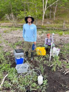
USGS intern and staff member make greenhouse gas measurements in a coastal wetland.
Lab Research Theme: Coastal wetlands occur at the nexus of population growth and dynamic environmental change, including rising sea level and temperature, enhanced nutrient loads, and landscape conversion. Salt marshes are coastal ecosystems that provide a wealth of services, including bird and fish habitat, storm surge protection and carbon burial. This last ecosystem service is of interest due to rising atmospheric carbon dioxide (CO2) levels primarily driven by the burning of fossil fuels and land use changes. My research at USGS focuses on the nexus of environmental biogeochemistry and ecosystem models to predict how these critical habitats respond to environmental stressors, such as sea-level rise, and management decisions, including managing hydrologic flow. We have a range of analytical capabilities, from field collections of sediment and water, to greenhouse gas measurements, to laboratory carbon and radionuclide analyses, as well as expertise in integrating models and data. We work collaboratively with scientists and land managers from WHOI, the Waquoit Bay National Estuarine Research Reserve, the Fish and Wildlife Service, the National Park Service and local management officials. We seek interns who are interested in coastal wetlands, with potential projects ranging from sediment coring and analysis, greenhouse gas measurements across wetland management gradients, dissolved carbon transport, and data-model integration. Potential Project Details: Nutrient and trace metal release following rewetting of an impounded wetland: A local field site is currently impounded, or restricted from daily tides, but a 2021 breach of the barrier sand dune resulted in flooding and rewetting, with salt marsh vegetation succession observed in 2022. Using field experiments, this project would investigate the release of nutrients and trace metals from sorbed pools on sediments into porewater and surface waters following seawater flooding using a variety of analytical techniques. This project would include fieldwork, laboratory work, and data analysis. Tracking wetland carbon respiration products (CO2 and CH4) across soil-water and water-air interfaces: Movement of water through coastal wetlands is critical to ecosystem resilience and is the main conduit for exchange between coastal wetlands, hotspots of biogeochemical interactions, and adjacent coastal regions. Carbon transport from wetlands to adjacent estuaries is an important component of the coastal ocean carbon cycle. This project will employ a trace gas analyzer to measure greenhouse gas exchange at plot scales across several coastal wetland field sites to test novel methods of tracing carbon flow via dissolved and gas fluxes. This project would include fieldwork, laboratory work, and data analysis. New skills and training: Depending on research focus, intern will gain field skills in greenhouse gas flux measurements; learn how to collect soil cores; perform a variety of laboratory methods; gain experience in wetland carbon cycle research; learn data analysis in R; and learn methods data presentation. Such activities are excellent preparation for geoscience careers. In addition, the candidate will have the opportunity to prepare and present the research results at a USGS Center meeting at the culmination of their internship. Woods Hole Coastal and Marine Science Center - Wetland Geochemistry and Coastal Resilience Meagan Eagle staff profile
Sedimentology and Sediment Geochemistry
Steve Phillips Read more
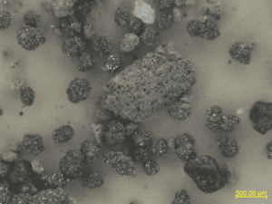
Example of a sand from the Alaska North Slope containing multiple mineral grains and rock fragments.
Lab research theme: Gas hydrates are ice-like solids composed of water and gas, most commonly methane, that are found within sediments in the cold temperatures and high pressures of deep marine and permafrost environments. Gas hydrates are of great interest as a major component of the global carbon cycle, a potential energy source, and a potential seafloor slope stability hazard. The USGS Gas Hydrates Project aims to advance the understanding of gas hydrates on continental margin and permafrost settings through US and international field expeditions, laboratory experiments, and numerical modeling. We often carry out this research as part of larger collaborations with other federal agencies and academic institutions. Our laboratory facilities in Woods Hole have capabilities to characterize various sediment properties and perform multiple biogeochemical measurements. Project details: The summer project will focus on better understanding the depositional environments and post-depositional diagenetic history of a permafrost-associated gas hydrate system on the North Slope of Alaska through microscopic observations, elemental analysis, and magnetic property measurements of sediments collected from borehole drill cuttings. These drill cuttings were recovered from permafrost formations and below-permafrost gas hydrate reservoirs. These sediments span the Paleocene to recent over a 1 km deep record that includes the Paleocene-Eocene Thermal Maximum. These compositional observations and analysis will help provide new insights on changes in depositional environment, sediment sources, and formation of authigenic minerals after deposition; all factors that provide context on paleoenvironmental changes in the Arctic over the Cenozoic, and the geological evolution of sub-permafrost gas hydrate systems. Interest/skill sets: We seek a summer student who is fascinated by sediments and sedimentary rocks and the geological history they reveal. A basic knowledge of mineralogy and petrology would be beneficial. New skills/training: The summer fellow will learn to use an optical microscope to identify major minerals and rock fragments in the coarse-grained size fraction (sand and gravel sized grains), describe grain textures, and estimate percentages of major constituents. The summer student will have the opportunity to measure quantitative elemental abundances using X-ray florescence and CNS elemental analysis and measure magnetic susceptibility on sediment samples. The summer student will also learn to plot trends in mineral abundance and geochemical composition, including ternary diagrams, to interpret past changes in depositional environment. These petrographic, stratigraphic, geochemical, physical property, and data integration skills are valuable for many geoscience career pathways. USGS Gas Hydrates Project Gas Hydrates Project Physical Properties Lab Steve Phillips profile