
Research Highlights
Oceanus Magazine
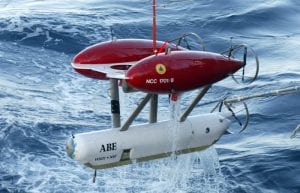
A pioneering deep-sea exploration robot—one of the first successful submersible vehicles that was both unmanned and untethered to surface ships—was lost at sea March 5, 2010, on a research expedition off the coast of Chile. The Autonomous Benthic Explorer, affectionately…
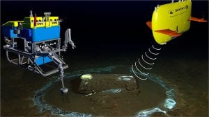
It’s a lot easier to send a bloodhound to track a criminal, or your kid to pick up groceries, than it is to get a deep-sea robot to find something on the seafloor. The dog will pick up the scent…

On the Serengeti Plains of Africa, lions stalk their prey mainly by sight. Scientists studying them also use their eyes to observe the hunt and indeed the entire ecosystem. They can take in the whole panorama, easily distinguishing lions from…
The marvelous migrations of fish and whales through the deep sea have been hard enough for us humans to follow. But what about tiny organisms—many smaller than the dot beneath this question mark? How they move from one spot to…

Brendan Foley hunts for shipwrecks, but he’s not searching for gold or jewels. The sunken treasure he pursues comes not in chests, but mostly in curvaceous clay jars called amphorae—the cargo containers of the B.C. world. Holding remnants of goods…
News Releases
The Royal Canadian Geographical Society, in partnership with WHOI, will undertake “once-in-a-generation” expedition to survey Sir Ernest Shackleton’s Quest and Captain Robert Falcon Scott’s Terra Nova
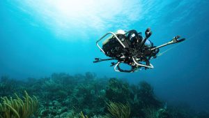
New underwater robot opens new possibilities in coral reef conservation by autonomously identifying biodiversity “hotspots”

Satellite measuring land, polar, and coastal regions could launch by 2030
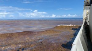
The findings point to warming ocean temperatures, shifting nutrient regimes, and changing circulation patterns as likely contributors to this emerging basin-scale redistribution of Sargassum.
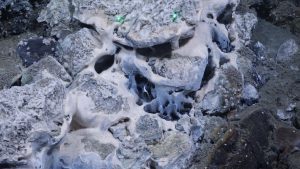
A distinctive oceanic core complex releasing hot fluids has been identified at a depth of 2,700 meters on the Arctic Ocean’s floor.
News & Insights
NSF program fosters collaboration between indigenous communities and traditional scientists, allowing WHOI’s autonomous vehicles to shed light on a changing Arctic
An investigative report this week in the LA Times features the work of WHOI’s marine geochemistry lab in identifying the discarded barrels and analyzing samples from the discovery.